Historical Markers in Louisiana by Parish
To see a picture click the code underlined next to "Marker"
Note: not all markers have picture
Parish: Ascension
City: Donaldsonville
Location: 305 Nichols Street at Louisiana Square
Latitude & Longitude: N 30° 06.283 W 090° 59.350
Picture on File: Yes Marker #LA-C-1
Text: Francis T. Nicholls
1834-1912
On this site directly across from this marker Francis T. Nicholls Confederate General, Governor, and Chief Justice of the State Supreme Court was born and reared.
Parish: Ascension
City: Donaldsonville
Location: SH 1, in front of St. Emma
Latitude & Longitude: 30° 4' 23.3616", -91° 1' 36.5736"
Picture on File: Yes Marker #LA-C-2
Text: St. Emma Plantation
Scene of Civil War skirmish in fall of 1862. C. 1850 Greek Revival plantation house owned 1854-1869 by Charles A. Kock, a prominent sugar planter. Listed on National Register of Historic Places in 1980.
Parish: Assumption
City: Labadieville
Location: SH 1, between Brule Rd. and Pine St.
Latitude & Longitude: 29° 50 18.906, -90° 57 12.924
Picture on File: No Marker #LA-D-1
Text: White Home
South 8 miles on Bayou Lafourche is birthplace of Edward Douglas White, Louisianas Confederate Soldier, Statesman, Journalist, and Chief Justice of U. S. Supreme Court.
Parish: Avoyelles
City: Cocoville
Location: Hwy 1 at Airport Rd., between Marksville & Mansura
Latitude & Longitude: 31° 6' 25.092", -92° 3' 47.502"
Picture on File: Yes Marker #LA-E-1
Text: Presentation Academy
Site of first Catholic school in Avoyelles Parish 1855. Founded by Daughters of the Cross of Treguier, France and Mother Mary Hyacinth Le Conniat on request of Bishop Martin. Battle of Mansura, May 16, 1864, began on convent grounds.
Parish: Avoyelles
City: Mansura
Location: 2392 Leglise St., Mansura
Latitude & Longitude: 31° 3 18.5292, -92° 2 52.1844
Picture on File: Yes Marker #LA-E-2
Text: Battle of Mansura
Confederate forces under General Dick Taylor here formed battle line may 16, 1864, barring passage of General Banks retreating Union Army. The battle of Mansura ended in withdrawal of the Confederates.
Parish: Avoyelles
City: Marksville
Location: District 8, near town
Latitude & Longitude: 31° 7 34.5468, -92° 4 2.4132
Picture on File: Yes Marker #LA-E-3
Text: Fort De Russy
Fort De Russy, four miles north, potent Confederate stronghold defending lower red River Valley, yielded to land attack of General A. J. Smiths Union Army on March 14, 1864.
Parish: Avoyelles
City: Simmesport
Location: SW intersection of hwy 1 and Hwy 1183
Latitude & Longitude: 30° 58' 54.5052", -91° 48' 40.9608"
Picture on File: Yes Marker #LA-E-4
Text: Battle of Yellow Bayou
Also known as Norwood's Plantation, fought May 18, 1864. Last battle of Bank's Red River Campaign. General Richard Taylor's Confederate army failed to prevent Union army crossing Atchafalaya River at Simmesport.
Parish: Avoyelles
City: Marksville
Location: downtown
Latitude & Longitude:
Picture on File: Yes Marker #LA-E-5
Text: Auguste Voinche Store
c. 1843
Oldest commercial building site remaining in city. Built by Voinche, native of Paris, France. Later Victorian upper structure on only basement in city. Basement used to hide cotton from Union troops during Civil War.
Parish: Beauregard
City: DeRidder
Location: Hwy 171, 12 miles S of DeRidder on the east side of the highway
Latitude & Longitude:
Picture on File: Yes Marker #LA-F-1
Text: The Old Confederate Military Road
In 1862, when the Federal troops captured New Orleans and blockaded the mouth of the Mississippi River, Taylors army, then in Central Louisiana, retreated from Banks army and it became necessary to furnish them with supplies. For this purpose a military road was established from Nibletts Bluff to Alexandria.
This marker is on the route of the Old Confederate Military Road through Beauregard Parish.
Parish: Beauregard
City: DeRidder
Location: Hwy 26 towards Oberlin from Hwy 171
Latitude & Longitude:
Picture on File: Yes Marker #LA-F-2
Text: The Old Confederate Military Road
In 1862, when the Federal troops captured New Orleans and blockaded the mouth of the Mississippi River, Taylors army, then in Central Louisiana, retreated from Banks army and it became necessary to furnish them with supplies. For this purpose a military road was established from Nibletts Bluff to Alexandria.
This marker is on the route of the Old Confederate Military Road through Beauregard Parish.
Parish: Bienville
City: Castor
Location: in town, Hwy 4 & Hwy 507 intersection
Latitude & Longitude: 32.252672,-93.166136
Picture on File: Yes Marker #LA-G-1
Text: Site of Kings Salt Works located ¼ mile west
Alfred Pickney King began salt operations at this site in the 1840s. During the Civil War, Kings Salt Works increased production to supply much needed salt to the Confederacy.
Parish: Bienville
City: Sparta
Location: SH 507, at old townsite of Sparta
Latitude & Longitude: N 32° 22.039 W 093° 04.774
Picture on File: Yes Marker #LA-G-2
Text: Sparta
SW 1/4 of SW 1/4 Sec 15 T16 NR8W
Founded 1849 as first parish seat for Bienville Parish. Post office est. 1849. 1st Postmaster J. M. Denson. Incorp. 1852. 1860 pop. Of 250 composed of merchants, craftsmen, and professionals. Had two churches, two Masonic lodges, and an indigents home. In 1862 organized Sparta Guards for the Confederacy. After the war railroad line came to parish but bypassed Sparta by six miles. 1892 parish seat moved to arcadia. Citizens gradually left. Post office closed 1924. Wm. Bates last postmaster.
Sponsors: Bienville Parish Police Jury and Sidney Myers
Parish: Bossier
City: Benton
Location: Burt Blvd. on Courthouse Grounds
Latitude & Longitude: N 32° 40.768 W 093° 44.650
Picture on File: Yes Marker #LA-H-1
Text: Confederate Monument
Cornerstone laid July 1, 1910 by members of R. J. Hancock Chapter, U.D.C. Formally unveiled on Tuesday, August 30, 1910, as a monument to the Confederate soldiers of Bossier Parish.
Parish: Bossier
City: Bossier Parish
Location: US 71, close to Bossier-Red River Parish Line
Latitude & Longitude: 32° 30' 43.9272", -93° 44' 19.5504"
Picture on File: Yes Marker #LA-H-2
Text: Loggy Bayou-Red River
Nearest point of Federal advance on Shreveport during Civil War. About four miles to southwest near confluence of streams Confederates sank steamer New Falls City which blocked passage of Federal gunboats, April 10, 1864.
Parish: Bossier
City: Fillmore
Location: LA-157 and Fillmore Cemetery Road
Latitude & Longitude: N 32° 33.421 W 093° 30.913
Picture on File: Yes Marker #LA-H-3
Text: Fillmore Cemetery
Located a short distance down this road. Founded 1848 by Fillmore Methodist church, once located on site. Buried here are Thomas D Connell, founder of Connells Cross Roads (now Fillmore), and W. P. Haughton. Also here is O.R. Gelette (1845-1944), one of the six last surviving Confederate commissioned officers, and the last surviving officer of General Lees staff.
Parish: Bossier
City: Taylortown
Location: US-71 about one mile south of Taylortown
Latitude & Longitude: N 32° 22.654 W 093° 35.049
Picture on File: Yes Marker #LA-H-4
Text: Ash Point Plantation
Built c.1875, was residence of Elam s. Dortch, believed to be last surviving Confederate veteran residing in Bossier Parish. Moved c. 1923 to present site from original location nearer river. Listed in National Register of Historic Places, 1982.
Parish: Bossier
City: Bossier
Location: Coleman Ave. in front of Bossier High School
Latitude & Longitude: 32.517866,-93.731759
Picture on File: Yes Marker #LA-H-5
Text: Fort Smith Memorial Park
This fort and park named for General Edmund Kirby Smith, Confederate States Army. Born St. Augustine, Florida, May 16, 1824. Graduate of West Point 1845. Distinguished for gallantry in Mexican War. Major in United States Army when Florida seceded. He resigned and was appointed Lieutenant Colonel, then Brigadier General Confederate States Army. Wounded at First Battle of Bull Run. Became one of the seven full generals of the Confederate States Army. Appointed to command Trans-Mississippi Department C.S.A. with headquarters at Shreveport, March 7, 1863, and commanded until May 26, 1865. The last Confederate Army to surrender. Died March 28, 1893, while professor at University of the South, Sewanee, Florida.
The Restored Remnant and Replica of Fort Smith
One of four forts and eighteen batteries which formed the Confederate defenses of Bossier (then Cane) City and Shreveport 1864-1865.
Park established and fort restored 1936 by Bossier Parish Police Jury, Sam D. Hunter, and Bossier City Council, Tom Hickman, Mayor, W. A. Gandy, W. M. McCall, H. A. Page, H. L. Parker, C. F. Shaver, Aldermen: G. C. Huckaby, Marshall. C. M. Brown, Engineer.
Parish: Bossier
City: Benton
Location: town square
Latitude & Longitude:
Picture on File: Yes Marker #LA-H-6
Text: Hughes House
Built in circa 1840 by Alex B. Hughes, the house remained in the Hughes family until its donation to the Bossier Restoration Foundation in 1972. This was the boyhood home of William Clark Hughes who was speaker of the Louisiana House of Representatives in 1928. This house has been used as an office, home, schoolhouse, and museum.
(second marker below on same post)
Originally built in Rocky Mount, Louisiana. From 1840s to 1860s it was the office of Stewman and Hughes plantation.
Site of the declaration of independence of the Free State of Bossier November 26, 1860, months before Louisiana seceded and the resulting War Between the States.
From 1860s-1880s private residence of Capt. William J. Hughes and family. During 1910s, office of Dr. John B. Hall. later coroner for Bossier Parish.
Home was preserved in 1960s by Bossier Restoration Foundation spearheaded by Dr. Webb H. Martin, Jr. until his death in 1978.
Donated to the Bossier Restoration Foundation in 1970s by the Hughes and OKelly descendants. moved to this site in 1995.
Parish: Bossier
City: Plain Dealing
Location: Hwy 157, just north of Redland Rd intersection
Latitude & Longitude:
Picture on File: Yes Marker #LA-H-7
Text: Army of Trans-Mississippi
General Churchills Division marching north from Shreveport along Red River turned east on Wire Road towards Red Land. 3 divisions by separate roads. Gen. E. Kirby Smith in command, they met at Calhoun-Magnolia, Ark. Plan; cut Federal supplies to Camden. support Gen. Sterling Price, and defeat Gen. Frederick Steeles Army at Jenkins Ferry.
In memory of Willie Inez Rogers Felknor
Parish: Caddo
City: Greenwood
Location: Hwy 80 at Nixon Street, in town
Latitude & Longitude: N 32° 26.608 W 093° 58.490
Picture on File: Yes Marker #LA-I-1
Text: Dunn Home
Built circa 1840. Used as a hospital for Confederate wounded following Battle of Mansfield in April, 1864. Several soldiers who died here are buried on the grounds.
Parish: Caddo
City: Shreveport
Location: SH 80
Latitude & Longitude: 32° 31 0.6024, -93° 44 38.5692
Picture on File: No Marker #LA-I-2
Text: Cane-Bennett Bluff
Trading Post established before July 1, 1832 by James Cane and William Bennett. Residence of Gen. Kirby Smith, Cmdr. Trans-Miss. Dept., CSA. Last Confederate Army to surrender in 1865.
Parish: Caddo
City: Shreveport
Location: Spring Street at Cross Bayou
Latitude & Longitude:
Picture on File: No Marker #LA-I-3
Text: Confederate Ironclad Missouri
Built 1863 one block east at Cross Bayou, with railroad T-rail and armor and guns from USS Indianola; surrendered at Alexandria June 3, 1865. CSN Webb aided in Indianola capture and was refitted here as a cotton-clad for dash to Gulf 1865.
Parish: Caddo
City: Shreveport
Location: N. Market St. north of Cross Bayou
Latitude & Longitude: 32° 33 59.3028, -93° 47 17.1528
Picture on File: Yes Marker #LA-I-4
Text: Confederate Navy Yard
One block west near mouth Cross Bayou at Red River the ironclad Missouri and ram Webb built. Missouri armored with railroad iron. In 1863 Webb fought U.S.S. Indianola near Vicksburg. Missouri was surrendered here May, 1865.
Erected by Louisiana State Tourism Commission 1975
Parish: Caddo
City: Shreveport
Location: 500 Block of Texas Street
Latitude & Longitude: N 32° 30.759 W 093° 44.995
Picture on File: Yes Marker #LA-I-5
Text: Caddo Parish Court House
Third courthouse to occupy this site since 1860. First courthouse on this site served as Louisianas Confederate Statehouse during Civil War. Present Courthouse designed by Neild & Somdal architectural firm. Built 1926-28. Served as model for numerous other government buildings throughout nation.
Parish: Caddo
City: Shreveport
Location: corner of Hwy 1 & Stoner Ave.
Latitude & Longitude: 32° 30 51.264, -93° 44 51.9252
Picture on File: Yes Marker #LA-I-6
Text: Fort Humbug
Formerly Fort Turnbull, built by the Confederates to defend Shreveport, then capital of Louisiana. In 1864, charred logs simulating cannon were used to deter Union forces from attacking.
Replacement marker sponsored by La. National Guard 2006
Parish: Caddo
City: Shreveport
Location: 912 Commerce Street
Latitude & Longitude: N 32° 30.743 W 093° 44.558
Picture on File: Yes Marker #LA-I-7
Text: Gen. E. Kirby Smith Residence
912 Commerce Street, 80 feet south of this corner, site of Benjamin L. Hodge home, where Gen. Smith lived 1863-65 while Commander of Trans-Miss. Dept. CSA. Built 1848; demolished 1960. Originally home of La. Supreme Court Judge Thomas T. Land.
Sponsored by Shreveport Sesquicentennial Committee
Parish: Caddo
City: Shreveport
Location: Spring Street, in town
Latitude & Longitude: N 32° 31.149 W 093° 45.169
Picture on File: Yes Marker #LA-I-8
Note: this marker is no longer in place
Text: Cross Bayou
One of Shreveports most historic waterways. Cross bayou is spanned by the old KCS railroad bridge one of only two surviving examples of the Waddell A-truss bridge design in America. On the south bank of Cross Bayou was the Confederate Navy Yard during the civil war.
Parish: Caddo
City: Shreveport
Location: Milam Street and Elvis Presley Avenue
Latitude & Longitude: N 32° 30.469 W 093° 45.228
Picture on File: Yes Marker #LA-I-9
Text: Oakland Cemetery
Earliest tombstone dated 1842. Cemetery officially opened 1847. At least 16 mayors are buried here as well as 1,000 Confederate veterans and soldiers. Fence and walls erected 1905, the same year it became to be officially called Oakland rather than City Cemetery. Listed in National Register of Historic Places 1977.
Parish: Caddo
City: Shreveport
Location: St Vincent Ave, between 73rd and 74th Streets
Latitude & Longitude: N 32° 26.249 W 093° 45.534
Text: Pickens Cemetery
Dating from the 1840s, this was once the family burial ground of the Pickens family, planters, of Caddo Parish. Among those buried here is Israel Wilson Pickens, Caddo Parish Sheriff from 1862-65, during which time Shreveport was Confederate Capital of Louisiana.
Parish: Caddo
City: Shreveport
Location: Veterans Hospital, at flagpole
Latitude & Longitude: 32.502627,-93.721286
Text: This marks the site of
Battery 1
One of the eighteen batteries and four forts which formed the Confederate defenses of Shreveport 1864-1865
Parish: Caddo
City: Shreveport
Location: Greek Orthodox Section of Greenwood Cemetery, Stoner Ave.
Latitude & Longitude:
Text: This marks the site of
Battery 3
One of the eighteen batteries and four forts which formed the Confederate defenses of Shreveport 1864-1865
Parish: Caddo
City: Shreveport
Location: Confederate Bivouac, Greenwood Cemetery, Stoner Ave.
Latitude & Longitude:
Text: This marks the site of
Battery 4
One of the eighteen batteries and four forts which formed the Confederate defenses of Shreveport 1864-1865
Parish: Caddo
City: Shreveport
Location: Marshall St. at Highland, near old Highland Hospital
Latitude & Longitude:
Text: This marks the site of
Battery 5
One of the eighteen batteries and four forts which formed the Confederate defenses of Shreveport 1864-1865
Parish: Caddo
City: Shreveport
Location: Murphy St. at Texas Avenue, on police station grounds
Latitude & Longitude:
Text: This marks the site of
Battery 7
One of the eighteen batteries and four forts which formed the Confederate defenses of Shreveport 1864-1865
Parish: Caddo
City: Shreveport
Location: Clyde Fant Parkway, in front of Shreveport Convention Center
Latitude & Longitude:
Picture on File: Yes (currently not at original location) Marker #LA-I-16
Text: This marks the site of
the former home of
Henry Watkins Allen
Civil War Governor of Louisiana
1864-1865
Also the site of Battery 10
One of the eighteen batteries and four forts which formed the Confederate defenses of Shreveport 1864-1865
Parish: Caddo
City: Shreveport
Location: SWEPCO Power Plant at Arsenal Hill (no public access)
Latitude & Longitude:
Text: This marks the site of
Battery 12
One of the eighteen batteries and four forts which formed the Confederate defenses of Shreveport 1864-1865
Parish: Caddo
City: Shreveport
Location: corner of Hwy 1 & Stoner Ave. on front entrance of Natl Guard Armory
Latitude & Longitude: 32.500587,-93.724279
Text: Fort Humbug Confederate Memorial
North of this building are the trenches and earthworks of Fort Humbug, the popular name for Fort Turnbull. largest and most important of the four forts and eighteen batteries with connecting trenches that formed the Confederate defense of Shreveport in 1863-65 when this city was the Confederate capitol of Louisiana and headquarters of the Trans-Mississippi department of the Confederate States Army. These fortifications were built under the direction of Lieut. Gen. E. Kirby Smith to protect Shreveport from attack by Federal forces under Maj. Gen. N. P. Banks in the famous Red River campaign of 1863-64. These forces were defeated however by the Confederate forces under Lieut. Gen Dick Taylor at the Battle of Mansfield April 8, 1864, forty-three miles southeast of Shreveport. The campaign ended and Shreveport saved without being attacked. Fort Humbug was so called because its scanty armament of cannon was largely supplemented for appearance by simulated guns made of logs.
The site of these buildings was donated by the City of Shreveport, with the concurrence of the United Daughters of the Confederacy, custodians of this park. These buildings were erected by the Police Jury and people of Caddo Parish and the State of Louisiana.
Parish: Caddo
City: Shreveport
Location: Veterans Hospital, at flagpole
Latitude & Longitude: 32.502627,-93.721286
Text: This marks the site of
Fort Turnbull
One of the eighteen batteries and four forts which formed the Confederate defenses of Shreveport 1864-1865
Parish: Cameron
City: Cameron
Location: Hwy 27 at Ann St., in town
Latitude & Longitude: 29° 47 43.4184, -93° 18 58.1292
Text: Battle of Calcasieu Pass
On May 6, 1864 Confederate troops attacked and captured the Union gunboats Wave and Granite City here. This was the only Civil War action in S. W. Louisiana. Many of the dead were buried on Monkey Island.
Parish: Cameron
City: Cameron
Location: Courthouse grounds
Latitude & Longitude:
Picture on File: Yes (this marker disappeared after Hurricane Rita) Marker #LA-L-2
Text: Confederate Medal of Honor Recipient
On May 6, 1864, Private William Guehrs of Creuzbaurs Battery 5th Texas Artillery sustained a serious wound to his leg while serving as gunner during the Battle of Calcasieu Pass. Guehrs received medical aid and remained with his gun although compelled by his wounds to swab and load the piece from his xxxx. Despite a deadly crossfire from two gunboats Guehrs continued to load his cannon until help arrived and both enemy gunboats were surrendered. On Sept. 3, 1864 Pvt. Guehrs died from his wounds.
Erected by Louisiana Society Order of Confederate Rose
Parish: Catahoula
City: Harrisonburg
Location: SH124/8, District 58, in town
Latitude & Longitude: 31.771284,-91.822207
Picture on File: Yes Marker #LA-M-1
Text: Fort Beauregard
One half mile west was one of four forts built by Confederates in May, 1863, to prevent the ascent of the Federal gunboats on the Ouachita River. It was abandoned 1863, but was reoccupied in 1864.
Erected by the Louisiana Department of Commerce and Industry 1955
Parish: Claiborne
City: Homer
Location: on courthouse square, N main at Hwy 9
Latitude & Longitude: 32° 47 31.092, -93° 3 19.9836
Picture on File: Yes Marker #LA-N-1
Text: Claiborne Parish Courthouse
Built in 1860, this antebellum building was the point of departure for Confederate troops during the War Between the States. It is one of the finest examples of Southern expression of Greek architectural style.
Parish: Desoto
City: Keachi
Location: Hwy 789 ¼ mile west of town in cemetery
Latitude & Longitude: 32.18863 093.90962
Picture on File: Yes Marker #LA-P-1
Text: Confederate Cemetery
Within this enclosure are the remains of over 100 Confederate soldiers. Following the Battle of Mansfield, many were infirmed at old Keachie College, where a morgue was established on the second floor of the main building.
Sponsored by Gen. Richard Taylor Camp #1308, Sons of Confederate Veterans, and Betty Youree Chapter #425, Children of the Confederacy (1986)
Parish: Desoto
City: Keachi
Location: Hwy 789 ¼ mile west of town
Latitude & Longitude: 32.18937 093.90962
Picture on File: Yes Marker #LA-P-2
Text: Keachi College
1856-1912
On this site stood a female college. Founded by Perry J. Backus of Good Hope (Keachi) Baptist Church on land donated by T. M. Gatlin. Became male & female institution in 1879. Served as hospital after Battle of Mansfield in 1864.
Erected by Keachi Heritage Foundation, Inc. 1988
Parish: Desoto
City: Mansfield
Location: on Hwy 175 at Mansfield SCA
Latitude & Longitude: 32° 00' 40.7", -93° 40' 04.8"
Picture on File: Yes Marker #LA-P-3
Text: Battle of Mansfield or Sabine Crossroads
April 8, 1864
Federal Battle Line at 4:00 P.M.~ First Phase of Battle
From this point the line extended about 400 yards north to a rail fence, thence East along the fence about 700 yards. It extended South about one half mile.
Parish: Desoto
City: Mansfield
Location: at Chatmans Bayou Hwy 175 S of Mansfield SCA
Latitude & Longitude: 31° 51 12.3 093° 37 22.9
Picture on File: Yes (this marker is gone) Marker #LA-P-4
Text: Battle of Mansfield or Sabine Crossroads
April 8, 1864
Federal Line at 6:00 P.M.~ Third phase of Battle
This point was called Chatmans Peach Orchard by Confederates and Pleasant Grove by Federals. Dark ended the fight for possession of water supply of Chatmans Bayou at foot of hill, where Confederates bivouacked. The Federals retreated to Pleasant Hill during the night.
Parish: Desoto
City: Stonewall
Location: Red Bluff Road, Lands End Plantation
Latitude & Longitude: 32° 14' 27.1896", -93° 45' 20.9268"
Picture on File: Yes (this marker is no longer there) Marker #LA-P-5
Text: Lands End Plantation 1835
Land's End Plantation est. 1835 by Colonel Henry Marshall, signer Louisiana Ordinance of secession and constitution of Confederate States of America; Member First Confederate Congress. House built 1857, used as hospital after Battle of Mansfield, 1864.
Erected by the Louisiana Tourist Commission 1969
Parish: Desoto
City: Mansfield
Location: on Hwy 175 N of Mansfield SCA
Latitude & Longitude: 32° 00' 40.7", -93° 40' 04.8"
Picture on File: Yes Marker #LA-P-6
Text: Battle of Mansfield or Sabine Crossroads
April 8, 1864
Area of Third Confederate Charge
Maj. Gen. Walker, with Wauls and Scurrys brigades, passed here parallel to the road during a charge that turned the Federal left flank and gained a position on the road in rear of Federal line.
Parish: Desoto
City: Mansfield
Location: on Hwy 175 N of Mansfield SCA
Latitude & Longitude: 32° 00' 40.7", -93° 40' 04.8"
Picture on File: Yes Marker #LA-P-7
Text: Battle of Mansfield or Sabine Crossroads
April 8, 1864
Area of second Confederate Charge
Randals Brigade of Walkers Texas Infantry Div. charged across this area traveling parallel to the road, supporting Moutons Division which made the first charge on Randals left.
Parish: Desoto
City: Mansfield
Location: on Hwy 175 N of Mansfield SCA
Latitude & Longitude: 32° 00' 48.0", -93° 40' 15.5"
Picture on File: Yes Marker #LA-P-8
Text: Battle of Mansfield or Sabine Crossroads
April 8, 1864
Confederate Battle Line at 4:00 PM
First Phase of Battle
From this point the line extended about 400 yards Northeast, thence East about a mile. It extended about a half mile South from here.
Parish: Desoto
City: Mansfield
Location: on Hwy 84 across from Iveys Do-It Center
Latitude & Longitude: 32° 02' 15.4", -93° 42' 05.7"
Picture on File: No (marker is gone) Marker #LA-P-9
Text: CSA General Headquarters
(need text)
Parish: Desoto
City: Mansfield
Location: on Hwy 175 between Mansfield and Pleasant Hill
Latitude & Longitude: 31.84802° -093.51044°
Text: Federal Hospital
Pierce and Payne College building used for a Federal hospital to care for soldiers wounded in the Battle of Pleasant Hill was near here.
Parish: Desoto
City: Old Pleasant Hill
Location: on Hwy 175 at the Old Pleasant Hill townsite
Latitude & Longitude: 31.85578° -093.51197°
Text: Cemetery
After the Battle of Pleasant Hill many brave men were put to rest here. Some wore gray, some wore blue.
Parish: Desoto
City: Mansfield
Location: on Hwy 175 at the Old Pleasant Hill townsite
Latitude & Longitude: 31.85575° -093.51311°
Text: Stage Coach Station
The stage coach station was at this point near the center of the village of Pleasant Hill.
Parish: Desoto
City: Mansfield
Location: Mansfield SHS, on the west end of the park on the Mouton Trail.
Latitude & Longitude:
Text: Battle of Mansfield or Sabine Crossroads
April 8, 1864
Rail Fence Used As Barricade
Here the Federal line extending from the South turned East along a rail fence forming a V. General Moutons Division charged this line in the bloodiest part of battle. In this, the first Confederate charge, General Mouton was killed and the gallant Polignac took command of his division.
Parish: Desoto
City: Old Pleasant Hill
Location: Hwy 175 at entrance to Pleasant Hill Battle park
Latitude & Longitude: 31.85329° -093.51386°
Text: Road to Cemetery
This road leads to old cemetery where soldiers of both armies, who fell in the Battle of Pleasant Hill, are buried.
Parish: Desoto
City: Old Pleasant Hill
Location: Hwy 175 at entrance to Pleasant Hill Battle park
Latitude & Longitude: 31.85320° -093.51366°
Text: The Old Cistern
Both Gen. Taylors and Gen. Banks troops obtained drinking water from this cistern while each army occupied Pleasant Hill during the Red River Campaign in April 1864. The stage coach station stood a few feet north of here.
Parish: Desoto
City: South of Mansfield
Location: South of Mansfield on Hwy 175
Latitude & Longitude: 31.92627° 093.58073°
Text: Federal Advance
April 7, 1864
Temporary Field Hospital
A short distance west of here facing the road, the home of William Robertson was used for the care of Federal Soldiers wounded in a skirmish near by. A mill behind the residence was used to grind grain for soldiers of both armies.
Parish: Desoto
City: South of Mansfield
Location: South of Mansfield on Hwy 175
Latitude & Longitude: 31.86117° -093.55648°
Text: Federal Advance
April 7, 1864
Wilsons Farm
From this point Gen. Greens Texas Cavalry drove Gen. A. L. Lees Federal Cavalry back toward Pleasant Hill until re-enforced. Then the Confederates withdrew, skirmishing all the way, to Ten-Mile Bayou.
Parish: East Baton Rouge
City: Baton Rouge
Location: in front of Old State Capitol
Latitude & Longitude: N 30° 26.824 W 091° 11.352
Picture on File: Yes Marker #LA-Q-1
Text: Old State Capitol
1850-1862, 1882-1932
This Gothic Revival structure was designed by James Harrison Dakin. The Louisiana Secession Ordinance was adopted here in January 1861. The interior was burned in December 1862 while the building was occupied by Federal troops. Reconstructed by William Freret in 1882, it served as the Capitol until 1932. The cast iron fence dates from 1854.
Parish: East Baton Rouge
City: Baton Rouge
Location: Park Blvd. & Wisteria St.
Latitude & Longitude: N 30° 26.567 W 091° 10.133
Picture on File: Yes Marker #LA-Q-2
Text: Civil War Battle
Colonel Henry Watkins Allen, later governor of Confederate Louisiana, was severely wounded near here in the Battle of Baton Rouge, August 5, 1862. He fell while leading his Louisiana brigade against an Indiana battery in position on Government near Seventeenth Street. The battery was supported by units of the 6th Michigan Regiment, part of the Union forces then holding the city.
Erected by the City of Baton Rouge
Parish: East Baton Rouge
City: Baton Rouge
Location: corner of State Capitol Dr. & N. Fifth St.
Latitude & Longitude: 30° 27 24.1848, -91° 11 9.2328
Picture on File: Yes Marker #LA-Q-3
Text: Arsenal Museum
This building, erected in c. 1835 as a powder magazine for a U. S. Army Post and Arsenal which used this area from 1810-1885, except in 1861-1862 when held by the Confederacy. In 1962 this building was restored and the museum established.
Parish: East Baton Rouge
City: Baton Rouge
Location: 19th St. in Downtown
Latitude & Longitude: N 30° 27.050 W 091° 10.083
Picture on File: Yes Marker #LA-Q-4
Text: Magnolia Cemetery
In 1852 the town of Baton Rouge bought this property for a cemetery. On these grounds, August 5, 1862 the major action of the Battle of Baton Rouge took place. Louisiana novelist Lyle Saxon is among prominent Louisianians buried here.
Parish: East Baton Rouge
City: Baton Rouge
Location: District 61, on Front Street
Latitude & Longitude: 30° 24 38.6064, -91° 11 10.8852
Picture on File: Yes Marker #LA-Q-5
Text: Pentagon Buildings
Constructed 1819-1822 to house U. S. troops. Used as a garrison from 1822-1977 except from 1861-62 when held by Confederates. From 1886-1925 these buildings and grounds were the site of Louisiana State University.
Parish: East Baton Rouge
City: Baton Rouge
Location: Third & Laurel Streets, in town
Latitude & Longitude: N 30° 27.028 W 091° 11.303
Picture on File: Yes Marker #LA-Q-6
Text: Fort Sumter Saloon
According to local tradition, Charles Weick named his newly purchased saloon the day after Fort Sumter was fired on, 1861, and put the cannon out front for atmosphere. It was one of the citys most popular saloons until prohibition.
Parish: East Baton Rouge
City: Baton Rouge
Location: Third Street near State capitol
Latitude & Longitude: N 30° 27.347 W 091° 11.309
Picture on File: Yes Marker #LA-Q-7
Text: Battle of Baton Rouge 1862
On August 5, 1862, Confederate troops from Alabama, Kentucky, Tennessee, Mississippi, and Louisiana under General John C. Breckinridge attacked from the east in an unsuccessful attempt to dislodge Union forces holding the city. Casualties were heavy, and the Union commander, General Thomas Williams, was killed. Williams forces, supported by Union gunboats, included men from Massachusetts, Connecticut, Vermont, Maine, Michigan, Indiana, and Wisconsin.
Parish: East Baton Rouge
City: Baton Rouge
Location: Greenwell Springs Rd.,in front of the State Hospital
Latitude & Longitude: N 30° 34.572 W 090° 59.642
Picture on File: Yes Marker #LA-Q-8
Text: Greenwell Springs
Named for the Greenwell family, a resort with a hotel, pavilion and cottages was developed here in the 1850s with stage service to and from Baton Rouge. General John C. Breckinridges Confederate troops camped here in August 1862. The hotel burned during the Civil War, and a later attempt to revive the resort failed. The state tuberculosis hospital was established here in 1923.
Parish: East Baton Rouge Parish
City: Zachary
Location: SH 64 & 964 in Zachary, LA
Latitude & Longitude: N 30° 39.283 W 091° 11.600
Picture on File: Yes Marker #LA-Q-9
Text: Port Hudson Siege
Seven miles west is site of anchor fort controlling Mississippi. Here 6500 Confederates held 30,000 Union troops May 21 until July 8, 1863. Fall of Port Hudson opened river, hastening fall of Confederacy.
Parish: East Baton Rouge Parish
City: Zachary
Location: SH 964 & Plains-Port Hudson Road
Latitude & Longitude: 30.690693,-91.205766
Text: Battle of the Plains Store
On May 21, 1863, a two-story building near this site housing Youngs store and the Plains Masonic Lodge was the center of a battle between Colonel William R. Miles Legion comprised of Confederate troops from Louisiana and units of General C. C. Augurs division of Union forces advancing on Port Hudson. Casualties: Union 100: Confederate, 89.
Parish: East Baton Rouge Parish
City: Baton Rouge
Location: 300 block of N 4th Street
Latitude & Longitude: 30.450151,-91.187
Text: Morgan Home Site
On this site stood the home where Sarah Morgan Dawson (1842-1909) wrote A Confederate Girls Diary which has become a Civil War classic. The diary depicts the occupation of Baton Rouge by Union forces.
Parish: East Baton Rouge Parish
City: Baton Rouge
Location: Greenwell Springs Road at Foster Drive
Latitude & Longitude: 30.462472,-91.139359
Picture on File: Yes (this marker no longer in place) Marker #LA-Q-12
Text: Lt. Alexander H. Todd C.S.A.
In the early hours of August 3, 1862, Lieutenant Todd, half brother of Mrs. Abraham Lincoln, was killed one-quarter mile southwest of here at a bridge over Wards Creek. He was fatally wounded in a mistaken exchange of fire between the Louisiana Partisan Rangers and General Benjamin H. Helms brigade, part of the Confederate forces preparing to attack Union troops occupying Baton Rouge.
Parish: East Baton Rouge
City: Baton Rouge
Location: Laurel and 17th Streets
Latitude & Longitude: 30.450965,-91.17111
Text: Civil War Battle of Baton Rouge 1862
On August 5, 1862, Confederate divisions of General Charles C. Clark and Donald Ruggles under General John C. Breckinridge attacked Federal forces of General Thomas Williams among tent camps of the 21st Indiana and 7th Vermont Regiments. Williams was killed near here. His troops fell back to positions nearer the Mississippi River reinforced by Federal gunboats.
Parish: East Carroll Parish
City: Lake Providence
Location: US 65, District 65
Latitude & Longitude: 32° 54 31.7286, -91° 13 34.1832
Picture on File: Yes Marker #LA-R-1
Text: Grants Canal
In early 1863, Federal General U. S. Grant dug a canal here connecting the Mississippi River and Lake Providence. This attempt to use the bayous and rivers to bypass Vicksburg failed.
Parish: East Carroll Parish
City: Lake Providence
Location: US 65, District 65
Latitude & Longitude: N 32° 48.653 W 091° 11.059
Picture on File: Yes Marker #LA-R-2
Text: Soldiers Rest
In early 1863, Union troops commanded by Gen. U. S. Grant dug a canal connecting the Mississippi River and Lake Providence. They camped in an area known as Soldiers rest, which provided a temporary home.
Parish: East Feliciana Parish
City: Jackson
Location: NE corner of Hwy 10 & Hwy 68, Jackson, La
Latitude & Longitude: 30.834906,-91.186041
Picture on File: Yes Marker #LA-S-1
Text: Site of Battle of Jackson Crossroads
At noon, June 20, 1863, at the crossroads, a long Union wagon train, escorted by 300 Union cavalry and 500 infantry, from the 52nd Mass. Vols., the 2nd Rhode Island, and Griersons 7th Ill. cavalry, was ambushed by a Confederate battalion of La. and Miss. cavalry, the 11th and 17th Ark., the 2nd Ark. cavalry, and Miss. Seven Star artillery who captured 50 of the 154 wagons. Casualties were light on both sides.
Parish: Iberia
City: Avery Island
Location: Avery Island Rd. at Marsh House Rd.
Latitude & Longitude: 29° 54 13.8276, -91° 54 37.3212
Picture on File: Yes Marker #LA-W-1
Text: First Rock Salt Mine
Salt evaporated from brine springs on Avery Island since 1791. On May 4, 1862, workman enlarging these springs to produce more salt for the Confederacy hit solid salt at a depth of 16 feet. Mining operations, the first of this type in North America, were begun and continued until the destruction of the salt works on April 17, 1863, by Union forces.
Parish: Iberia
City: Jeanerette
Location: US 90, District 3, in town
Latitude & Longitude: 29° 54 34.3224, -91° 42 47.3508
Picture on File: Yes Marker #LA-W-2
Text: Beau Pre Circa 1828
This home, originally known as Pine Grove, was bought in 1830 by John W. Jeanerette, the first postmaster between New Iberia and Charenton, and for who Jeanerette is named. This historic home escaped the destruction of military operations in the area during the Civil War.
Parish: Iberia
City: New Iberia
Location: SH 45, on E. Main Street
Latitude & Longitude: 29° 59 45.0816, -91° 47 59.352
Picture on File: Yes Marker #LA-W-3
Text: Frederick Larned Gates
Former home of Frederick Larned Gates (1827-1897), outstanding citizen, businessman, lawyer, and Civil War veteran. He served as district judge in the 1870s and 1880s. As an early industrialist, Gates developed a cotton seed oil business which was one of the areas major enterprises.
Erected by the Louisiana Tourist Development Commission 1972
Parish: Iberia
City: Spanish Lake
Location: SH 182, District 3
Latitude & Longitude:
Picture on File: Yes Marker #LA-W-4
Text: Site of Camp Pratt
From 1862-1863 Camp Pratt was official Confederate camp of conscription and instruction for South Louisiana. At one time as many as 3000 conscripts here. A small compound for Union prisoners of was also located at the camp.
Parish: Iberville
City: White Castle
Location: Hwy 405, S. of town
Latitude & Longitude: N 30° 13.500 W 091° 09.250
Picture on File: Yes Marker #LA-X-1
Text: A Civil War Soldier
West of this marker lies the grave site of a Union Soldier who was killed in a skirmish with Confederate soldiers at Bayou Goula on January 25, 1865. his name is believed to be private David Ingraham, Third Rhode Island Cavalry, Company H. he was given a Christian burial by Mrs. Florestine Lambremont Richard and was buried under an Oak tree at the rear of the Lambremont Plantation, He was twenty years old.
Parish: Jefferson
City: Bridge City
Location: 2141 River Rd., Westwego
Latitude & Longitude: 29° 57 3.4794, -90° 9 10.65096
Picture on File: Yes Marker #LA-Z-1
Text: Magnolia Lane
Area known as Nine Mile Point; site of Fortier Plantation and one of areas first schools, churches, and later site of WWI commissary. Once the home of Francois Quinet, Sr., statesman and developer of early New Orleans; nearby was site of Fort Banks which blockaded River during Civil War.
Parish: Jefferson
City: Metairie
Location: River Road
Latitude & Longitude: N 29° 57.562 W 090° 09.417
Picture on File: Yes Marker #LA-Z-2
Text: Camp Parapet
In 1862 Confederate and Louisiana authorities laid out Camp Parapet as part of the defense lines of New Orleans. The works were designed to protect the city against an attack from the north. After the Federals, coming up from the south, captured New Orleans, Camp Parapet became an important part of the Union defenses. It served also as a training camp for Northern soldiers.
Parish: Jefferson
City: Westwego
Location: Hwy 18 near River Road
Latitude & Longitude: N 29° 55.488 W 090° 08.744
Picture on File: Yes Marker #LA-Z-3
Text: Seven Oaks Plantation Site
Formerly Petit Desert, a 1719 concession among first parish settlements. it was a trading post and major entry port of the Louisiana colony. 1794 Michael Zeringue established Seven Oaks Plantation. His son, Camille, built Greek Revival style main house c. 1840. During War, occupied by Confederates, then Federals. Following the war, property acquired by Columbia Gardens Resort and later by railroad. During WWI house served as Army barracks. Later returned to private residence. Vacated in 1957, the house was demolished in 1977.
Parish: Jefferson
City: Gretna
Location: Huey P. Long Avenue between 1st & 2nd Streets, adjacent to memorial arch
Latitude & Longitude: 29.917559,-90.066283
Picture on File: Yes Marker #LA-Z-4
Text: Phoenix Iron Works
Approx. 200 feet SW of this site, cast first gun for the Confederate Navy on 4 May 1861. The gun, a Dahlgren cannon, fired an 8-inch diameter explosive shell. Sylvester Bennett was proprietor.
Jefferson Parish Historical Commission
Parish: Jefferson
City: Grand Isle
Location: 3811 Hwy 1
Latitude & Longitude: 29.230987,-89.998004
Picture on File: Yes Marker #LA-Z-5
Text: Fort Livingston
Two miles N.E. on Grand Terre. Land occupied by Jean Lafitte until 1814, purchased by U. S. from Etienne DeGruy 1834. Fort constructed 1841 to defend Barataria Pass. Site never saw combat. Abandoned after the War Between the States, guns were removed 1872. Named for Edward Livingston, U.S. Secretary of State , 1831-1833.
Sponsored by the Jefferson Parish Historical Commission 2010
Parish: Lafayette
City: Lafayette
Location: University Ave.
Latitude & Longitude: 30° 12 34.9524, -92° 0 30.6792
Picture on File: Yes Marker #LA-CC-1
Text: General Alfred Mouton
1829-1864, Confederate brigadier general from Lafayette who served in Shiloh, Lafourche, Teche, and Red River campaigns. Killed at Mansfield, leading Confederacy to its most important military victory west of the Mississippi.
Sponsored by Alfred Mouton Chapter, United Daughters of the Confederacy
Parish: Lafayette
City: Lafayette
Location: Hwy 90, S of Albertson parkway
Latitude & Longitude: 30° 8 19.7916, -91° 56 43.458
Picture on File: No Marker #LA-CC-2
Text: Battle of Vermillionville
Confederate forces under General R. Taylor and immediate command of General Alfred Mouton, who was killed at Mansfield, defended Teche valley. Here they fought a rear guard action with Federal forces led by General N. Banks, 1863.
Parish: Lafayette
City: Lafayette
Location: Pinhook Rd. at Bayou Vermillion
Latitude & Longitude:
Text: Bayou Vermillion
Battle of Pinhook Bridge
April 17, 1863
Battle of Bayou Vermillion
October 9, 1863
We honor the memory of those soldiers who valiantly fought on these banks.
Lafayette Parish Bayou Vermillion District
Parish: Lafourche
City: Thibodaux
Location: SH 1, between Landry and Ridgefield at Nichols Shopping center
Latitude & Longitude: 29.796206,-90.82803
Text: Francis Tillou Nicholls
(1834-1912)
Homesite of distinguished Confederate brigadier general, twice governor of Louisiana 1877-80 and 1888-92; he was appointed Chief Justice of the Louisiana State Supreme Court, serving from 1892-1911.
Erected by the Louisiana Tourist Development Commission 1968
Parish: Lafourche
City: Thibodaux
Location: SH 20, District 2, in town
Latitude & Longitude: 29° 47' 47.7132", -90° 49' 7.5756"
Text: St. Johns Episcopal Church
One of the oldest Episcopal churches in the Mississippi Valley. St. Johns Parish organized February, 1843. Cornerstone of church laid January, 1844. Church consecrated, March, 1844, by Bishop Leonidas Polk, first Episcopal Bishop of Louisiana.
Parish: Lafourche
City: Thibodaux
Location: Hwy 308, S. of town
Latitude & Longitude: N 29° 46.143 W 090° 45.939
Text: Battle of Lafourche Crossing
Major General Richard Taylor sent an expedition under Colonel James P. Major to break Union supply lines, disrupt Union activities and force an enemy withdrawal from Brashear (Morgan) City and Port Hudson. Major set out from Washington, Louisiana, on Bayou Teche, heading south and east.While marching, his men he conducted raids on Union forces, boats, and plantations and in the process captured animals and supplies and liberated slaves.
Brigadier General William H. Emory, commanding the defenses of New Orleans, assigned Lieutenant Colonel Albert Stickney to command in Brashear City and to stem the Rebel raid if possible. Emory informed Stickney of Major's descent on LaFourche Crossing and ordered him to send troops. Feeling that no threat to Brashear City existed, Stickney, himself, led troops off to LaFourche Crossing, arriving on the morning of the 20th.
That afternoon, Stickney's scouts reported that the enemy was advancing rapidly. The Rebel forces began driving in Stickney's pickets around 5:00 pm. Confederate cavalry then advanced but was driven back. After the Union troops fired a few rounds, the Confederates withdrew in the direction of Thibodeaux.
In the late afternoon of the 21st, Confederate soldiers engaged the Union pickets, and fighting continued for more than an hour before the Rebels retired. About 6:30 pm, the Confederates reappeared in force, started an artillery duel, and charged the Union lines at 7:00 pm. An hour later, the Confederates disengaged and retired toward Thibodeaux.
The Union held the field. Despite the defeat, Major's raiders continued on to Brashear City.
Parish: Livingston
City: Walker
Location: Hwy. 190, in front of Walker Town Hall
Latitude & Longitude: N 30° 29.267 W 090° 51.817
Text: Walker, Louisiana
Originally named Milton Old Field for Michael Milton who claimed land in 1853. Walker post office established in 1856. Named for Wm, E. Walker, M.D. state legislator and organizer of Co. D 16th La. Inf., C.S.A. Town incorporated in 1909.
Erected by Town of Walker
Parish: Madison
City: Tallulah
Location: Courthouse grounds, Depot St at N Cedar
Latitude & Longitude: N 32° 24.462 W 091° 11.235
Text: Tallulah
Tallulah was founded in 1857. In 1862 it was an important telegraph and railroad station on the Vicksburg, Shreveport, and Texas Railroad. On August 18, 1862, the depot, telegraph office, and several cars were destroyed by a small detachment of Federal troops under Col. W.D. Bowen. The depot contained a large amount of sugar and supplies for the Confederate Army.
Parish: Madison
City: Tallulah
Location: Thomastown rd. & Ashley Plantation Rd.
Latitude & Longitude: 32° 26.296' N, 91° 7.396' W
Text: Battle of Millikens Bend
At daybreak on June 7, 1863, Gen. H. E. McCulloch led his Texas Brigade against the Union force which guarded the Union supply depot at Millikens Bend. In the savage fighting which ensued, the Confederates drove the Federals from their camp. While many of the Texans stopped to plunder the encampment, the Federals took cover behind a levee fronting the river. Here, supported by fire of the ironclad Choctaw, the Federals were able to check the Confederates. McCulloch withdrew. This was the second battle in which Negro troops were employed by the North.
Parish: Madison
City: Tallulah
Location: La 602, S of I-20 at Crescent Plantation Dr., SE of town
Latitude & Longitude: N 32° 22.185 W 091° 09.820
Text: Crescent Plantation
During the Civil War, Crescent was the home of Dr. D.M. and Elizabeth DeMoss Dancy. The house was built in 1832.
When Gen. U.S. Grant's Federal forces occupied Madison Parish, an officer and several soldiers came to Crescent with orders to burn the house, but did not because a sick lady, a member of the Dancy family, was in the home. The mansion is still standing, and in excellent state of preservation.
Parish: Madison
City: Tallulah
Location: Thomastown Road, N of Hwy 80, NE of town
Latitude & Longitude: N 32° 26.302 W 091° 07.383
Text: Grants March
The succeeding markers identify the route of march by Gen. U.S. Grant through Louisiana. Erected 1962 by
Jimmie H. Davis, Governor of Louisiana
Louisiana Civil War Centennial Comission:
R.J. Breaux Rep. Jesse M. Knowlee
John Regard Frederic R. Swigart
Sen. Sylvan Priedman, Chairman Mrs. Frank J. Fava
Rep. Bryan J. Lehmann, Jr. Mrs. J.B. Shackelford
O.W. Welch Dr. T. Harry Williams, Vice president
Mrs. Elaine Ventress Johnson, Sec. and Treas.
Louisiana Department of Commerce and Industry
Henry J. Davis, Executive Director
Police Jury of Madison Parish
Andrew L. Yerger N.L Kell
Warren Patrick Frank Stewart
R.B. Watts R.C. Webb, Jr.
Jim S. Folk W.F. Powell
Baskin Parks J.A. Clark
Police Jury of Tensas Parish
Clyde B. Lee Russell Y. Ratcliff
E.M. Roberts R.E. Lancaster, Jr.
E.R. McDonald Harvey Trevillios
G.C. Goldman
Parish: Madison
City: Tallulah
Location: Thomastown Road, NE of Tallulah
Latitude & Longitude: N 32° 25.085 W 091° 05.733
Text: Dalkeith Plantation
This home was used to confine Confederate prisoners during Gen. U.S. Grant's occupation of Madison Parish. This is one of the two ante-bellum houses still standing in Madison Parish. The home is located several hundred feet from this marker on the opposite side of the bayou.
Parish: Madison
City: Tallulah
Location: Near Duck Port Rd on Thomastown Rd, NE of town
Latitude & Longitude: N 32° 23.627 W 091° 02.852
Text: Duckport Canal
On March 31, 1863 ground was broken for the Duckport Canal. This canal connected Duckport Landing on the Mississippi River with Walnut Bayou. By utilizing this canal, Gen. U.S. Grant hoped to open a navigable route to New Carthage via Walnut and Roundaway Bayous. The tug "Victor" reached New Carthage. A number of barges and two of the dredges were trapped in the waterway when a phenomenal drop in the stage of the Mississippi River forced abandonment of the canal.
Parish: Natchitoches
City: Goldonna
Location: SH 156, Vine St.
Latitude & Longitude: 32° 0 52.884, -92° 54 28.2384
Picture on File: No Marker #LA-II-1
Text: Drakes Salt Works
First noted by Bienville in 1700, this site is one of the oldest salt wells in Louisiana. First used by the Indians, it provided a major supply of salt for the Confederate forces during the War Between the States.
Parish: Natchitoches
City: Marthaville
Location: Rebel State Park, 1260 Hwy 1221, N of Marthaville
Latitude & Longitude: 31.749664,-93.426833
Text: Grave of Unknown Confederate Soldier
Here lies an unknown Confederate, killed by Union troops, April 2, 164, during Red River Campaign. This soldier had been cut off from his unit following a skirmish at nearby Crumps Hill. He was shot at this site while attempting to rejoin other Confederate troops.
Erected by the Louisiana Tourist Development Commission, 1971
Parish: Natchitoches
City: Marthaville
Location: on entrance road to Rebel State Park, 1260 Hwy 1221, N of Marthaville
Latitude & Longitude: 31° 45 02.2, 093° 25 33.7
Picture on File: Yes Marker #LA-II-3
Text: William Hodge Barnhill
In memory of William Hodge Barnhill, his family and descendants. Here on his homeplace April 3, 1864 he and his sons buried a Confederate soldier killed by Union forces. This gravesite was maintained by the Barnhill family for 98 years.
Parish: Orleans
City: New Orleans
Location: Confederate Memorial Hall, 929 Camp Street
Latitude & Longitude: 29.943407,-90.071175
Text: Confederate Memorial Hall
Louisianas Oldest Museum
Dedicated January 8, 1891
Designed by Thomas Sully, Architect to harmonize with the adjoining structure, then the Howard Memorial Library. Built as a repository for records, reports, artifacts, and memorabilia of the Civil War by Frank T. Howard and donated to the Louisiana Historical Association as a memorial to his father Charles T. Howard.
The remains of Jefferson Davis, first president of the Confederacy, who died in New Orleans, lay in state in Memorial Hall on May 29, 1893.
The museum, which is owned and operated by the Louisiana Historical Association (founded April 11, 1889) was placed on the National Register of Historic Places June11, 1975.
Parish: Orleans
City: New Orleans
Location: Lafayette Cemetery #1 entrance
Latitude & Longitude:
Text: Lafayette Cemetery No. 1
Established in 1833 by
The City of Lafayette
The square was acquired from Cornelius Hurst and the cemetery laid out by Benjamin Buisson, City Surveyor
This was part of the Livaudais Plantation which had been subdivided into city squares in 1832.
The cemetery contains many fine and historic tombs, among them those of Samuel Jarvis Peters, father of the New Orleans public school system and General Harry T. Hays, distinguished Confederate general.
Here are buried many persons of German and Irish origin who lived in the city of Lafayette.
The typical New Orleans burial vaults adjoining Washington Avenue were restored and magnolia trees on the cross aisle replanted by the city of New Orleans.
Victor H. Schiro, Mayor 1970
Parish: Plaquemines
City: Belle Chasse
Location: River Road, District 2
Latitude & Longitude: 29° 53 24.306, -89° 54 36.9936
Picture on File: No Marker #LA-LL-1
Text: Fort St. Leon
Designed by De Verges and garrisoned in 1754, but abandoned in 1792. Because of strategic value it was rebuilt by Latour in 1808 and garrisoned to defend New Orleans. Destroyed by Adm. Farragut during Civil War in advance up the river.
Parish: Plaquemines
City: Venice
Location: Hwy 23, in town
Latitude & Longitude: 29° 16' 33.6432", -89° 21' 23.5656"
Text: Fort Jackson
Built around 1822-32 to protect the lower river. Named for Andrew Jackson. 1862 - Fort withstood 10 day siege by Farragut and surrendered after city fell. In 1898 and 1917-18 used as training base. 1961-Fort was declared a national monument.
Parish: Pointe Coupee
City: Erwinville
Location: SH 90, District 61, near town
Latitude & Longitude: 30° 32' 0.7908", -91° 24' 28.8252"
Picture on File: No Marker #LA-MM-1
Text: Randall Oak
On False River, 11.5 miles north, where James Randall wrote Maryland, My Maryland. And 8 miles north is Parlange Plantation home, containing many early Louisiana relics.
Parish: Pointe Coupee
City: Fordoche
Location: Hwy 10, 5 mi. N of town
Latitude & Longitude: N 30° 41.667 W 091° 39.300
Text: Battle of Bayou Fordoche
On Sept. 29, 1863, Confederate forces of Texas and Louisiana commanded by Brig. Gen. Tom Green defeated Union forces of the 13th Army Corps capturing 500 men and 2 cannons. The battle is also known as the Battle of Sterlings Plantation. This marker is dedicated to the men that died on this battlefield.
Erected by the Louisiana Society Order of Confederate Rose
Parish: Pointe Coupee
City: Innis
Location: St. Stephens Episcopal Church, Hwy 418 N. of town
Latitude & Longitude: 30.89703 -91.66821
Text: St. Stephens Episcopal Church and Cemetery
Began as St. James mission in 1848. Reorganized as a parish in 1855 named after the first martyr at the suggestion of Bishop Leonidas Polk, the Fighting Bishop of the Confederacy. The church and cemetery grounds were consecrated by Bishop Polk in 1859. The church was constructed using hand-made bricks. The stained glass windows were made in England. The Confederate Monument in the Cemetery was erected and dedicated in 1904. Restoration of the Church was completed in 1978. A massive restoration of the cemetery was completed 1991.
Parish: Pointe Coupee
City: New Roads
Location: 9789 False River Road
Latitude & Longitude: 30.671747,-91.474292
Text: Randall Oak
Near this tree, within the walls of Poydras College were written the immortal lines of Maryland, My Maryland by James Ryder Randall. Born in Baltimore, Maryland, January 1st, 1839, Died in Augusta, Georgia, January 14th, 1908. Poem written at midnight April 26th, 1861.
This tablet is erected to his memory by the Book Club of Point Coupee Parish
April 26th, 1938
Parish: Rapides
City: Alexandria
Location: downtown, in front of library, Washington & 5th Streets
Latitude & Longitude: 31.309282,-92.444758
Text: Alexandria Library
This site, located in the towns center square, was set aside for public use on the original town plat commissioned by Alexander Fulton in 1805. The building was constructed solely for advancement of culture and learning in 1907 by Caldwell Brothers, Contractors, and Crosby & Henkel of New Orleans, Architects. It replaced an earlier library burned by Gen. Nathaniel Banks federal troops May 13, 1864. Area businessman S. S. Bryan matched a $10,000.00 grant from Pittsburgh philanthropist Andrew Carnegie. The funds were given for a free public library with the stipulation that the City provide a site and maintenance forever. An accepting ordinance was adopted by Alexandrias Board of Aldermen may 7, 1907. The Alexandria City Council in 1971 adopted a resolution designating the building as the Alexandria Historical and Genealogical Library and Museum. It was restored as a Bicentennial project. Through the date of placing this marker, 1990, the building remains in public ownership as the Citys only public building over 75 years old used for its original purpose. It was placed on the National Register of Historic Places January 19, 1989.
Sponsored by Dorothy Tudor McWherter
Parish: Rapides
City: Alexandria
Location: in the downtown mini-park
Latitude & Longitude:
Text: Thomas Courtland Manning
1825-1887
On this site in 1906, the City Library known as the Manning Memorial Library was opened, named in honor of a 19th century resident who served his State and Nation. Hundreds of his personal volumes were donated to this library, which ceased operation a year or so later.
Born in Edenton, North Carolina, he became an attorney by reading-for-the-law. Albemarle Sentinel editor, educator at Edenton Academy, and Master of the Equity Court, Chowas County.
In 1855, he moved his family to Alexandria. Their residence was eight blocks west, bounded by Second, Third, Madison, and St. Anne streets, and faced Red River.
His majority accomplishments in life were; Member of first Board of Supervisors for La. Seminary (LSU); Adjutant General of La. C. S. A. 1863-1864; Assoc. Justice of La. Supreme Court C. S. A. 1864-1865; Chief Justice of La. Supreme Court 1877-1880; Assoc. Justice of La. Supreme Court 1882-1886; U. S. Minister Plenipotentiary to Mexico 1886-1887.
Parish: Rapides
City: Alexandria
Location: 1201 Third Street
Latitude & Longitude: 31° 18' 38.5956", -92° 26' 36.6324"
Text: Old Courthouse Square
Rapides was one of the twelve original counties created when the Territory of Orleans was divided in 1805. Records are not available about early courthouses on this square, which was reserved for public use by the towns founder in a plat of February 1, 1805.
A new courthouse built in 1859 was destroyed by fire on May 13, 1864, by federal troops evacuating Alexandria in retreat down the Red River. Legal records and much of the town were burned. Hard times delayed the replacement courthouse until 1873. A parish jail was built on the Lee Street corner in 1899.
The last courthouse on this site, costing $75,000, was occupied in 1904. In 1940, a new, still existing courthouse was built on Murray Street. The jail was soon demolished; the old deteriorating courthouse was razed in 1957. The square was later acquired by McCormick & Co. for use by the Town Talk. (Alexandria Town Talk on reverse.)
Sponsored by the Alexandria Town Talk.
Parish: Rapides
City: Alexandria
Location: Corner of Main and Murray Streets
Latitude & Longitude: N 31° 18.705 W 092° 26.649
Text: Rapides Parish Governors
Four 19th century Rapides Parish residents served Louisiana as governor.
Joseph Marshall Walker (1784-1856), a Bayou Rapides cotton planter, was governor 1850-1853- the first to be installed in the newly designated Baton Rouge capitol. During his administration, improvements were made in water and railway transportation, telegraph lines built, levees and drainage improved, and a state banking system established.
Thomas Overton Moore (1804-1877), a Bayou Robert planter, was governor 1860-1864, including the two month period of independence when Louisiana had seceded from the Union but had not joined the Confederacy. During his term, the capitol was twice moved to escape the Federal troops invasion.
James Madison Wells (1808-1899), a Bayou Boeuf plantation owner, was elected lieutenant governor of federally-occupied Louisiana in 1864 and served as governor from 1865 to1867. He sought reconciliation between unionists and Secessionists.
Newton Crain Blanchard (1849-1922), born and reared on Bayou Jean de Jean, was governor 1904-1908. His administration was known for progressive reform.
Erected by the City of Alexandria
Parish: Rapides
City: Alexandria
Location: 3rd St. between Johnston and Murray Streets
Latitude & Longitude: N 31° 18.667 W 092° 26.662
Text: Alexandria
Unnamed during the colonial period, Alexandrias beginnings as the major city in Central Louisiana are traced to c. 1797, when the seat of justice for Rapides Post was transferred from the north to the south bank of Red River. By 1799, the greater percentage of the population was located here. Growth was rapid, spurred by the introduction of the cotton gin in 1800 by Alexander Fulton. Within two years, Fulton had began clearing land, opening roads, and in 1805, Frederick Walther, Fultons surveyor, laid out the Town of Alexandria. The plat contained eighty square blocks between present-day Jackson Street, Tenth Street, Overton Street, and the river, surrounded a public square. Tradition holds that the towns name honored a young Fulton daughter. Following the Louisiana Purchase of 1803, Alexandria became the seat of justice when an act creating Rapides County became law on April 10, 1805. Trade, business, and agriculture gained greatly with the advent of steamboat service. In late December 1814, the first steamboat, Enterprise, captained by Henry Miller Shreve, docked at Alexandria.
In 1818, the State Legislature granted Alexandria a charter. Because of the rapids immediately to the north, the town was the head of navigation for Red River from July to January. This created growth as a shipping point, with such institutions as newspapers (1810), semi-public schools (1818), banks (1823), and libraries (1824) being founded.
During the decades preceding the Civil War, Alexandria became the most important trade and social center for the plantation system in Central Louisiana. As a result of agricultural activity, the first railroad west of the Mississippi was constructed in 1837 by Ralph Smith-Smith, with the depot located at the courthouse square.
Alexandria was the focus of military activity in Louisiana during the last two years of the Civil War. The town was designated Headquarters for the Confederate Trans-Mississippi Department by the order of Lieutenant General E. Kirby Smith on March 7, 1863. Two months later, Alexandria was briefly occupied by a raiding Union force under the command of General Nathaniel P. Banks supported by naval forces under Admiral David D. Porter.
A second invasion of the Red River valley in April 1864 by the Union under the same officers was repelled by Confederate forces under the command of General Richard Taylor. In their retreat, Union troops burned Alexandria, destroying all courthouse and municipal records; the date was Friday, May 13, 1864.
Sponsored by the City of Alexandria
Parish: Rapides
City: Alexandria
Location: US 71/167, District 8, near town
Latitude & Longitude: 31° 12 41.6304, -92° 25 30.8568
Picture on File: No Marker #LA-NN-6
Text: Thomas Overton Moore
Leader in the secession movement and Confederate Governor of Louisiana 1860-1864. This is site of Moreland, his plantation home, burned by Banks retreating Union Army in Spring 1864.
Parish: Rapides
City: Alexandria/Pineville
Location: US 71N, near Central La. State Hospital
Latitude & Longitude: N 31° 19.619 W 092° 26.908
Text: Fort Buhlow and Fort Randolph
Fort Buhlow and Fort Randolph were earthwork/moat fortifications constructed beginning October 1864, by Confederate forces anticipating a repetition of Union General Nathaniel Banks summer 1864 Red River Expedition. Construction, completed by March 1865, was under the command of Capt. C. M. Randolph, and supervised by a Military Engineer, Lt. A. Buhlow, for whom the forts are named. The work was performed by about 1,500 soldiers and civilian workers and 500 black slaves. A third and larger fort, planned for the Alexandria side of the river, was never built. There was a Confederate troop build-up in the Alexandria area in March 1865, and the Confederate ironclad Missouri was anchored in the river opposite Fort Randolph, but the anticipated attack never came and no fighting ever took place. On May 26th, Gen. Simon Buckner surrendered all Confederate forces in the Trans-Mississippi area, and Union forces under Gen. Phillip Sheridan occupied Buhlow and Randolph on June 2, 1865. Fort Buhlow is now a State Park. Fort Buhlow is located approximately 60 yards upstream (north) of the O. K. Allen Bridge on U. S. Highway 71. Fort Randolph is located approximately 600 yards downstream (South) from the bridge.
Sponsored by Thomas Overton Moore Chapter, United Daughters of the Confederacy
Parish: Rapides
City: Camp Beauregard
Location: at the camp
Latitude & Longitude:
Picture on File: No Marker #LA-NN-8
Text: Camp Beauregard
World War I
Camp Beauregard, activated in July 1917 and named for General Pierre Gustave Toutant Beauregard, was the home of the 39th Infantry Division of Arkansas, Mississippi, and Louisiana.
Parish: Rapides
City: Pineville
Location: at cemetery
Latitude & Longitude:
Picture on File: No Marker #LA-NN-9
Text: Alexandria National Cemetery
The Alexandria National Cemetery, Pineville, was authorized by an Act of Congress on February 22, 1867, and the United States, through the Secretary of War, took possession April, 1871, of this property from the Succession of Francois Poussan. The parcel containing 8.24 acres was valued by United States Judge W. B. Woods in the amount of $1,200.00, pursuant to an order of the United States District Court signed May 21, 1875.
The cemetery was originally enclosed with a picket fence, later replaced with a brick wall in 1870. Lodge built in 1879, rebuilt in 1931. Sun porch added in 1938 by W. P. A. labor. Flag mound and flagstaff replaced in November 1950.
Initially there were 1,378 internments, 837 unknown, 507 known. Later the following transfers were made to three common graves. 1,514 unknown soldiers originally interred in Fort Brownsville, Texas, as casualties of the Civil War were interred in one grave.
In a second grave, 25 unknown soldiers were transferred from post and private cemeteries near old Fort Jessup, Louisiana.
A third grave bears the remains of 16 unknown soldiers originally interred at Fort Ringo, Texas. During World War II, five German prisoners of war were given internment.
In 1973, the responsibility for operation of the cemetery was transferred to the Veterans Administration Hospital.
Parish: Rapides
City: Pineville
Location: US 165, in town
Latitude & Longitude: N 31° 19.619 W 092° 26.908
Text: Baileys Dam
About ½ mile downstream is the site of Col. Joseph Baileys noted dam, which allowed escape on May 13, 1864, of the Federal Fleet of some 35 vessels under the command of Admiral David A. Porter.
Parish: Rapides
City: Alexandria
Location: Murray St., N of main Street
Latitude & Longitude: 31° 18.745' N, 92° 26.624' W.
Text: Red River
Twenty-seven miles southeast of Tucumcari, New Mexico, Red River originates in the watershed of the Frio Draw on the Llano Estacado at an elevation of about 5000 feet. Flowing eastward through Palo Duro Canyon, it subsequently forms the border between Texas and Oklahoma, then turns southeast across Louisiana joining the Mississippi River at the northern boundary of the Florida Parishes. Its distinctive red color and rich alluvial valley have been noted since the earliest European explorations in the 17th century. Following the Louisiana Purchase, the U. S. sent the Freeman-Custis Expedition in 1806, to explore Red River and refute Spanish border claims. The first steamboat, the Enterprise, ascended the Red River to Alexandria in 1814, but transportation above Natchitoches was blocked by the Great Raft until cleared by Capt. Henry Shreve in 1833-38. (continued on other side)
Erected by Red River Waterway Commission
Red River
(continued from other side)
During the Civil War, the Unions Red River Campaign was an important part of the Trans-Mississippi hostilities. The Great Raft gradually reformed but was cleared again in 1873. By the turn of the century, river transportation had succumbed to rail competition and silting due to flood control levees. For almost 100 years, commercial river transportation was non-existent until the Red River Waterway Project again made it feasible with a system of locks and dams. Lindy Claiborne Boggs Lock and Dam No. 1 at Lower Brouilette was dedicated November 9, 1984: John H. Overton Lock and Dam No. 2 ay Ruby was dedicated November 21, 1987: Lock and Dam No. 3 was dedicated May 26, 1992. Congress authorized funding for additional locks and dams for navigation the reach Shreveport-Bossier.
Erected by Red River Waterway Commission
Parish: Red River
City: Lake End
Location: Lock & Dam #4 Access Road
Latitude & Longitude: N31° 56.077' W93° 17.986'
Text: C.S.A. Brigadier General Tom Green
April 12, 1864, C.S.A. Brig. Gen. Tom Green was killed near here leading his Texas cavalry in a duel against the Union monitor Osage, gunboat Lexington, and the transport Black Hawk at the Battle of Blairs Landing. Of his passing Lt. Gen. Richard Taylor, said Green was upright, modest, and with the simplicity of a child, danger seemed to be his element, and he rejoiced in combat
His death was a public calamity and mourned as such by the people of Texas and Louisiana.
Erected by Louisiana Society Order of The Confederate Rose 2008
Parish: St. Charles
City: Boutte
Location: US 190, in town
Latitude & Longitude: 29° 54 3.8808, -90° 23 29.3784
Text: Skirmish of Boutte Station
Union train with sixty men ambushed by Confederate force of Louisiana militia and volunteers on September 4, 1862. Train escaped to New Orleans. Fourteen Union soldiers killed and twenty-two wounded in the skirmish.
Parish: St. Charles
City: Des Allmands
Location: US 90, District 2, in town
Latitude & Longitude: 29° 47' 0.8268", -90° 31' 19.2036"
Text: Battle of Des Allemands
Le district des Allemands, settled by German about 1720, the scene of numerous skirmishes between Confederate guerillas and Union forces, 1862-1863. Most famous skirmish resulted in capture of an entire detachment of Union soldiers on September 4, 1862.
Parish: St. Charles
City: Hahnville
Location: SH 18, District 2, in town
Latitude & Longitude: 29° 57 20.5596, -90° 24 9.0504
Text: Fashion Plantation
Home of General Richard Taylor, son of Zachary Taylor, Louisiana Statesman and member of 1861 Secession Convention. Commanded Louisiana District, 1862-64; defeated Banks at Battle of Mansfield, 1864. Federals plundered home in 1862.
Parish: St. Helena
City: Grangeville
Location: Hwy 63 & Hwy 37 intersection
Latitude & Longitude: 30° 44' 24.5184", -90° 50' 6.7344"
Picture on File: No (this marker no longer in place) Marker #LA-TT-1
Text: Williams Bridge
Bridge site nearby. In Civil War on route from Camp Moore to Mississippi River. Skirmish here on June 28, 1862. Breckenridges Confederates crossed here in August 1862 and Griersons Federal Raiders on May 1, 1863.
Parish: St. James
City: Hymel
Location: SH 18, District 2, in town
Latitude & Longitude: N 29° 58.950 W 090° 49.833
Text: Cabahanoce Plantation St. James
House long since claimed by the river was home of Andre Bienvenu Roman (1831-35 and 1839-43), Governor of Louisiana (1845 and 1852), member Constitutional Convention (1861), Member Secession Convention, Member peace Commission to Washington, D. C. for Confederacy.
Parish: St. James
City: Vacherie
Location: SH 18, District 2, in town
Latitude & Longitude: N 30° 00.317 W 090° 44.333
Text: Colonel Leopold L. Armant
Enlisted in Confederate Army, 1861; died heroically at Battle of Mansfield, 1864. Served in Yellow Jacket Battalion. Commandant of 18th Volunteer Infantry Regulars and Mouton Brigade. His ancestors were Jean Marie, Jean Baptiste, and Jean Seraphim Armant, St. James planters and army officers.
Parish: St. James
City: Vacherie
Location: SH 20, District 2, near Chegby
Latitude & Longitude:
Picture on File: No Marker #LA-UU-3
Text: Le Chemin Militaire
Route used by Civil War troops. It led from Mississippi River over swamp ridges, Indian trails, through Chackbay (Chegby), Thibodaux and Bayou Lafourche areas, Schriever, Gibson, Morgan City, to Attakapas country. Local militia units took active parts in Civil War engagements.
Parish: St. James
City: Convent
Location: Hwy. 44, next to the post office
Latitude & Longitude: N30° 00.733 W 090° 49.667
Picture on File: No Marker #LA-UU-4
Text: Judge Poche Plantation House
Felix Pierre Poche, Civil War diarist, Democratic party leader, prominent jurist and one of founders of American Bar Association, built this Victorian Renaissance Revival style plantation house with unusual front dormer c. 1870.
Erected by Department of Culture, Recreation, and Tourism
Parish: St. John the Baptist
City: Edgard
Location: SH 18, District 2, in town
Latitude & Longitude: 30° 2' 45.4812", -90° 33' 34.5888"
Picture on File: No Marker #LA-VV-1
Text: St. John the Baptist Catholic Church
From which civil parish was named. First church on second German Coast when Louisiana was colony of Spain. Served west and east banks of river until 1864. Old cemetery contains grave of wife of Gen. P. G. T. Beauregard and John Slidell family tomb.
Parish: St. Landry
City: Linwood
Location: 169 County Ridge Rd.
Latitude & Longitude: 30° 29 53.0016, -92° 4 13.314
Picture on File: No Marker #LA-WW_1
Text: Linwood
1 mile SW. Built c. 1848 by Albert G. Carter. A portion of Sarah Morgan Dawsons A Confederate Girls Diary was written here. Bombardment of Port Hudson and other events at Linwood are described in this important Civil War source.
Parish: St. Landry
City: Opelousas
Location: Courthouse Grounds, W. Landry at S. Market
Latitude & Longitude: N 30° 31.997 W 092° 05.014
Text: Opelousas
Poste des Opelousas founded by French traders middle of 18th century. Headquarters district of Opelousas under Spanish 1769. Parish seat of Old Imperial St. Landry 1808. State Capitol 1862-63.
Erected by the LA Dept of Commerce and Industry 1959
Parish: St. Landry
City: Opelousas
Location: Courthouse Grounds, W. Landry at S. Market
Latitude & Longitude: N 30° 32.000 W 092° 05.025
Text: Opelousas
Capital of Confederate Louisiana. May 1, 1862 ~ January 23, 1863.
After the Union occupation of New Orleans and surrounding territory in the spring of 1862 the state offices were moved to Opelousas. From here Governor Thomas Moore issued an address to the people urging them to continue the struggle, and the state legislature met here in December, 1862. But in January 1863, rumored Federal offensives caused the removal of the Capital to Shreveport. On April 20 Union forces occupied Opelousas but soon left to take part in the first Red River campaign.
Parish: St. Landry
City: Sunset
Location: Napoleon Ave., SH 182 & 754
Latitude & Longitude: 30° 25.094' N, 92° 5.54' W
Text: Confederate Mass Grave
While Texas will mourn the loss of her brave sons, she will treasure the memory as the glorious martyrs of our common country's independence." The above words echo from the report of Colonel O. M. Roberts regarding men of the 11th, 15th & 18th Tx. Inf. buried in a grave near here. The men died in the Battle of Bayou Borbeux in 1863.
Erected by the Texas and Louisiana OCR Societies
Parish: St. Landry
City: Sunset
Location: Chretian Point Plantation, Chretian Point Road
Latitude & Longitude: N 30° 23.355 W 092° 05.932
Text: Semmes Battery
In memory of two unknown soldiers of Semmes Battery 1st Confederate Light Artillery who lost their lives on 10/15/1863 during the Battle of Little Carrion Crow Bayou. Their names may have been forgotten but their devotion to duty and country have not. Erected by the LA. Society Order of Confederate Rose 2002.
Parish: St. Martin
City: Breaux Bridge
Location: St. Joseph Catholic Church Cemetery
Latitude & Longitude: 30° 20' 14", -91° 51' 18"
Text: Louis Hebert
Approximately 100 yards to the west is the probable resting place of General Louis Hebert, C. S. A. Born in Iberville Parish in 1820, Hebert was graduated from West Point in 1845 third in his class. After an army service of two years, he resigned to manage his familys sugar interests. Before the war he was a member of the state senate and chief engineer of Louisiana. During the war he fought at Wilsons Creek, Elkhorn Tavern, Iuka, Corinth, Vicksburg, and Fort Fisher. He was an editor and teacher after the war in Iberville and St. Martin Parishes and lived until 1901.
(this marker was moved to its present location when the General was re-interred at St. Joseph)
Parish: St. Mary
City: Bisland
Location: US 182, near Calumet Bridge
Latitude & Longitude: 29° 41 51.5472, -91° 22 4.0512
Text: Battle of Bisland
April 12-13, 1863
Gen. Nathaniel P. Banks Union army attacked Gen. Dick Taylors Confederate forces entrenched at Fort Bisland. Confederates repulsed each attack, but post evacuated when Union flanking force landed at Irish Bend.
Erected by Office of Culture, Recreation, and Tourism 1981
Parish: St. Mary
City: Franklin
Location: US 90, District 3,in town
Latitude & Longitude: 29° 45 50.6124, -91° 29 5.2908
Picture on File: No Marker #LA-YY-2
Text: Battle of Franklin
Gen. Richard Taylors 1,600 man Confederate Army fought severe delaying battle here against 4,000 federals under Gen. Cuvier Grove April 14, 1863, before retreating toward Opelousas.
Parish: St. Mary
City: Franklin
Location: Courthouse Grounds, Willow St. at West Main
Latitude & Longitude: N 29° 47.490 W 091° 30.004
Text: Battle of Irish Bend
Also called by the Confederates the battle of Nersons Woods or Franklin. In the Teche campaign the Federals followed the retreating Confederates from Bisland. Units of the Federal army under Gen. C.C. Grover landed from transports on Grand Lake and were engaged by the Confederates under Gen. Richard Taylor two miles northeast of this site. Meanwhile other Federals under Gen. Godfrey Weitzel entered Franklin from the east, forcing Taylor to abandon his lines. A stubborn delaying action by Gen. A.A. Mouton enabled Taylor to cross Bayou Yokeley and march to Jeanerette up the old Iberia Road.
Parish: St. Mary
City: Franklin
Location: Courthouse Grounds, Willow St. at West Main
Latitude & Longitude: N 29° 47.489 W 091° 30.007
Text: The Gunboat Diana
Embedded in the banks of Bayou Teche to the east of this site and visible from here are the boilers of the gunboat Diana. Originally a Federal vessel operating on the lower Teche, it was captured by the Confederates. During the Bisland campaign, under the command of Oliver J. Semmes, son of the Confederate raider, Admiral Raphael Semmes, the Diana effectively harassed the attacking Federals. Damaged in the fighting, the ship was fired by her crew to prevent capture.
Parish: St. Mary
City: Franklin
Location: US 90, District 3,in town
Latitude & Longitude: 29° 45 50.6124, -91° 29 5.2908
Text: Donelson Caffery
1835-1906
Site home of Donelson Caffery, courageous soldier of the Confederacy; distinguished lawyer and sugar planter of St. Mary Parish; able and uncompromising member of United States Senate (1892-1901); a most influential figure in the history of Louisiana.
Parish: St. Mary
City: Franklin
Location: Hwy 90 median at Tourist Center
Latitude & Longitude: N 29° 48.450 W 091° 32.202
Text: Jefferson Davis Louisiana Association
Jefferson F. Davis was born in Kentucky June 3, 1801. In 1810 his family moved to St. Mary Parish settling on Bayou Teche. He graduated West Point, was a hero of The Mexican War, a US Representative, Senator, Secretary of War, and Regent of the Smithsonian. He served as President of the Confederate States of America (1861-65). He died December 6, 1889 in New Orleans and was buried in the Army of Northern Virginia tomb in Metairie Cemetery. Three years later re-interred in Hollywood Cemetery in Richmond, VA.
By; Louisiana SCV-Young Sanders Center
Parish: St. Mary
City: Morgan City
Location: US 90, District 3, in town
Latitude & Longitude: N 29° 41.595 W 091° 12.100
Text: Fort Star
Also known as Fort Brashear. Near this site, now occupied by Atkinson Memorial Presbyterian Church, was the larger of two works erected to defend Morgan City, then Brashear City and a Federal military depot. On the night of June 22, 1863, 325 Confederates of Gen. A.A. Moutons command landed from skiffs and flats in rear of the town. Attacking the next day, they captured the garrison of 700 Federals and immense military stores, while suffering losses of only 3 killed and 18 wounded.
Parish: St. Mary
City: Morgan City
Location: US 90, District 3, in town
Latitude & Longitude: 29° 41 37.5144, -91° 11 6.8892
Picture on File: No Marker #LA-YY-8
Text: Fort Brashear
(also known as Fort Star)
Located one half mile south. This Union fort was the scene of an important military engagement on June 23, 1863, resulting in the Confederate capture of 700 Federal troops and immense military stores.
Parish: Tangipahoa
City: Hammond
Location: In Front of Historic District Welcome center
Latitude & Longitude: N 30° 30.233 W 090° 27.667
Text: City of Hammond
Railroad came through in 1854. Became a shoemaking center for the Confederacy during the Civil War. Town was planned in the 1860s , and by early twentieth century was known as Strawberry Capitol of America.
Erected by the Department of Culture, Recreation, and Tourism 1979
Parish: Tangipahoa
City: Kentwood
Location: US 51, District 62, in town
Latitude & Longitude:
Text: Roncal
Site of Civil War home of Charles Etienne Arthur Gayarre, Louisiana historian, lawyer, judge, legislator, and Secretary of State 1846-1853. Grandson of Etienne de Bore.
Parish: Tangipahoa
City: Ponchatoula
Location: in front of depot
Latitude & Longitude: 30° 26 19.6512, -90° 26 29.274
Text: Ponchatoula Depot
Original depot built by c. 1854 by New Orleans, Jackson & Great Northern Railroad (later Illinois Central). Burned when Union forces captured town in March 1863. Rebuilt c. 1865. Present depot built in 1894 and remodeled in the 1920s.
Parish: Tangipahoa
City: Tangipahoa
Location: US 51, N. of town
Latitude & Longitude: 30° 36' 57.1428", -90° 29' 42.2124"
Text: Camp Moore
One of the principal Louisiana Confederate induction centers and training camps during the War for Southern Independence. Named for Governor Thomas Overton Moore. Over 400 soldiers buried in the camp cemetery.
Erected by the LA Dept of Commerce and Industry 1959
Parish: Tangipahoa
City: Tangipahoa
Location: District 62, in town
Latitude & Longitude: 30° 36' 57.1428", -90° 29' 42.2124"
Text: Tangipahoa
Area settled in early 1800s. New Orleans, Jackson & Great Northern Railroad built station here c. 1853. One square mile town formed around it in 1866. Included part of former Confederate Camp Moore. Town named for Indian tribe.
Erected by Department of Culture, Recreation, And Tourism 1982
Parish: Tangipahoa
City: Ponchatoula
Location: Hwy. 51, 1 mile South of Ponchatoula
Latitude & Longitude:
Text: 1862 Train Wreck
Near this spot on February 27 1862 a southbound lumber train collided with a northbound troop train carrying men of Col. Edmund J. Goodes 7th Mississippi Infantry in route to join the Confederate army in Tennessee. The lumber train had failed to move onto a siding as the northbound train approached. In the fog of the early morning, while most of the men were sleeping, the terrible crash occurred. The first two wooden passenger cars were torn apart with splinters of wood causing death to 22 men at the scene, mortally wounding another 6 men and seriously injuring 10 more. All of the dead and most serious injured were members of the Dahlgren Rifles of Pike Co., MS and the Quitman Rifles of Franklin and Amite Counties. A medical team from the C. S. Hospital in New Orleans and volunteers from nearby Ponchatoula provided assistance to the injured and dying. After the victims were removed and the tracks cleared, the regiment continued on its journey to Tennessee. They would earn the respect of friend and foe as part of Mississippis High Pressure Brigade
Erected by Friends of Camp Moore
Parish: Tensas
City: Newellton
Location: LA 608 just East of Winter Quarters SCA
Latitude & Longitude: N 32° 01.143 W 091° 09.657
Text: Hard Times Landing
By the morning of April 29, 1863, Gen. U.S. Grant had concentrated the XIII Corps at Hard Times. Two divisions and part of another were embarked on transports and barges to spearhead the invasion of Mississippi.
By 7:50 A.M., seven of Adm. D.D. Porters ironclads started down the Mississippi River. Porter had been given the mission of knocking out the guns mounted in the Grand Gulf forts. For more than five hours the ironclads and the Confederate forts blasted away at each other. When Porter reported that he was unable to knock out the Confederate guns, Grant called off his attack on Grand Gulf. The troops were disembarked and marched overland to Disharoons plantation. Here, they rendezvoused with Porters gunboats and transports which had passed Grand Gulf under the cover of darkness. The next day (April 30) Grants army made an unopposed landing at Bruinsburg, Mississippi.
Parish: Tensas
City: Newellton
Location: Winter Quarters SHS, LA 608 S of town
Latitude & Longitude: N 32° 01.087 W 091° 09.945
Text: Winter Quarters Plantation
Winter Quarters Plantation was owned by Haller Nutt during the Civil War. the plantation was used as an overnight stopping point by thousands of Federal troops on their march to Hard Times. The first to arrive was Col. J. Keigwins force, which spent the night of April 28, 1963 here.
Winter Quarters was the only plantation home of the fifteen along Lake St. Joseph left standing after the Union march.
Grants march through Louisiana was part of the Union campaign to capture Vicksburg on the Mississippi River.
Parish: Tensas
City: Newellton
Location: US 65 and LA 898 (near LA 575)
Latitude & Longitude: N 32° 10.833 W 091° 13.992
Text: Hovey Cuts a Road
The flooded countryside between Pointe Clear and New Carthage forced the Federals to look for another way to reach Somerset. Gen. A.P. Hoveys division was given the task of opening the road known to bound Bayou Vidal on the West.
Leaving Dawsons plantation on April 21, 1863 Hoveys Troops marched to Dunbars plantation. Here the Federals discovered a mile and one-half of the road between Mill and Nigger Bayous was under water. Hoveys engineers bridged Bayou Vidal. The road was cut through the heavy timber on the east side of the stream, and a slough was bridged. Reaching a point below the flooded area, Hoveys soldiers bridged Bayou Vidal a second time. Much of this work was of the hardest kind, the soldiers having to labor in water up to their necks. By April 26th, the three bridges, totaling 962 feet in length, were open for traffic. During the next several weeks, thousands of Union troops followed the route pioneered by Hovey.
Parish: Tensas
City: Newellton
Location:
Latitude & Longitude:
Text: Franklin Plantation
At the time of the Civil War, Franklin Plantation was owned by Dr. Allen T. Bowie. Other planters of this prosperous section of Louisiana owned more property and grew more bales of cotton, but Dr. Bowies mansion was the grandest. A Confederate from Missouri reported the St. Joseph country was unsurpassed in beauty and richness by any of the same extent
in the world.
The officers in charge of the XIII and XVI Corps kept a tight rein on their troops, and the stately mansions were unharmed as they marched southward. When the troops of gen. W. T. Shermans XV Corps pressed forward to join Gen. U. S. Grant in his invasion of Mississippi, his soldiers got out of hand. On May 6, 1863 a number of rowdies from gen. J. M. Tuttles division burned most of the mansions which faced Lake St. Joseph, including Dr. Bowies.
Parish: Terrebonne
City: Gibson
Location: in town, in front of church
Latitude & Longitude: N 29° 41.250 W 090° 59.217
Text: Gibson Methodist Episcopal Church
Erected 1849 on land donated by Cornelius and John Wallis. During Civil War church was used as a hospital. Entered National Register of Historic Places may 8, 1986.
Parish: Terrebonne
City: Houma
Location: Hwy. 659 (E. Park Ave.) south of Houma
Latitude & Longitude: N 29° 35.850 W 090° 41.383
Text: Residence Plantation
Queen Anne Revival style house built in 1898 by Roberta Volumnia Barrow Slater. Constructed using materials from a house built on the same site in 1854 by her parents noted Louisiana planter Robert Ruffin Barrow and Volumnia Hunley barrow, sister of famed Confederate submariner Captain H. L. Hunley.
Parish: Terrebone
City: Houma
Location: 243 Barrow St. in Houma
Latitude & Longitude: N 29° 35.817 W 090° 43.133
Text: St. Matthews Episcopal Church
Chartered on May 15, 1855 by the Rt. Rev. Leonidas K. Polk, first Episcopal Bishop of Louisiana. The first building was erected in 1858. Present cypress structure was completed 1892. During the War Between the States its first Rector , the Rev. Moses E. Wilson, served as a Union Army Chaplain. Its second Rector, The Rev. George W. Stickney, served as a Confederate Army Chaplain. In 1989 St. Matthews was listed on the National Register of Historic Places.
Parish: Vernon
City: Burr Ferry
Location: Hwy 8, near Sabine River
Latitude & Longitude:
Text: Burrs Ferry Earthworks
On July 2, 1863, during the Red River Campaign, Confederate General John Bankhead MacGruder issued orders that East facing fortifications be built in 3 locations along the Sabine Nibletts Bluff, Burrs Ferry, and Logansport. Constructed first and considered by MacGruder as most important, Burrs Ferry could hold 2,500 men and was built under the direction of Major General William R. Scurry. This cremaillere type of fortification allowed marksmen to fire in different directions, and consisted of mounds, ditches, and redans, areas for cannon placement, as well as exhibiting a special feature, tetes de pont, or head of bridge, designed for defending roads leading to river crossings. This is the only surviving tetes de pont in Louisiana. An original remnant of the Texas Beef Trail still exists here. Burrs Ferry earthworks was added to the National Regoster of Historic Places in 2004.
Erected by the Vernon Parish Tourism Commission 2004
Parish: Vernon
City: Leesville
Location: Courthouse Grounds, 3rd Street
Latitude & Longitude:
Text: Vernon Parish Founders
John R. Smart Father of Vernon Parish introduced act to create parish. Served in Louisiana House and Senate before and after war between the states: signed 1852 Louisiana Constitution. Named Leesville for Gen. Robert E. Lee. A successful planter, his home, The Retreat, was four miles north of Leesville. Dr. Edmund E. Smart, The Father of Leesville served in Louisiana House and Senate. Developed the city on his plantation and served the new city as treasurer in 1871. He donated the city block for the Vernon Parish Courthouse.
Erected by Vernon Parish Tourism Commission
Vernon Parish Police Jury 2001
Parish: Webster
City: Doyline
Location: SH 164/165, District 4, in town
Latitude & Longitude: 32° 32' 18.5388", -93° 20' 50.01"
Picture on File: No Marker #LA-HHH-1
Text: Lake Bistineau
Steamboat channel created by Red River log jam in 1793. Twelve miles south is Lake Bisteneau State park, near a salt dome where salt was manufactured by some 1,500 people during the War Between the States blockade.
Parish: West Baton Rouge
City: Brusly
Location: Located on River Road, in Brusly
Latitude & Longitude: N 30° 24.167 W 091° 13.267
Text: Antonia Plantation
A typical raised Creole cottage, Antonia was an early 1800s working sugar plantation. Established through a 1793 Spanish Land Grant claimed by Pierre Lebert. Zephirin Blanchard married Leberts daughter Elsie and expanded the plantation. Zephirin Blanchard fought in the War of 1812. His son Arthur fought and died in the Civil War. Antonia Plantation was owned by the Blanchard Levert family for over 200 years.
Erected by the Becnal Family 2008
Parish: West Baton Rouge
City: Port Allen
Location: US 90, in town
Latitude & Longitude: 30° 21 36.1908, -91° 15 38.2788
Text: Allendale Plantation
Home of Second Louisiana Confederate Governor Henry Watkins Allen. Purchased from Colonel William Nolan in 1852 for $300,000, which included 125 slaves. House burned by Federal troops during the War.
Parish: West Baton Rouge
City: Port Allen
Location: LA 415, in town
Latitude & Longitude: 30° 29 58.3548, -91° 15 12.9024
Picture on File: No Marker #LA-III-3
Text: Rosedale Road (LA Hwy. 986)
Over the Rosedale Road in May 1864 marched the Union Army of Major General Nathaniel Banks on its return to New Orleans following the failure of the Red River Campaign.
Parish: West Feliciana
City: St. Francisville
Location: Ferdinand St., church grounds
Latitude & Longitude: 30.775432,-91.38615
Text: Grace Episcopal Church
As one of Louisiana's oldest protestant churches, its history began in 1827 in St. Francisville; Investiture came in 1829, with Bishop Polk's Visitation in 1839. Shelled during Civil War, the Church began, rebuilt, with final restoration in 1880s.+
Erected by the Louisiana Tourist Commission 1969
Parish: West Feliciana
City: St. Francisville
Location: US 61, near town
Latitude & Longitude: 30.83761,-91.335174
Picture on File: No (this marker is missing) Marker #LA-KKO-2
Text: Locust Grove
Cemetery four miles east is burial place of Sarah Knox Davis, daughter of President Zachary Taylor and first wife of Jefferson Davis, President, Confederate States of America.


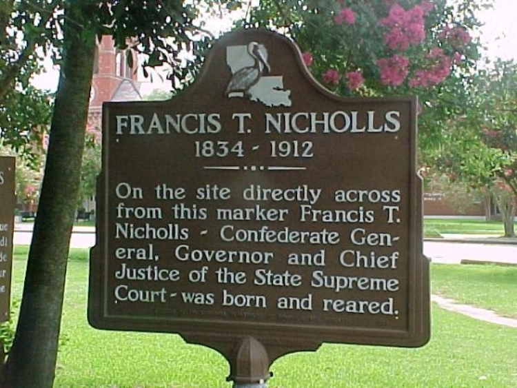
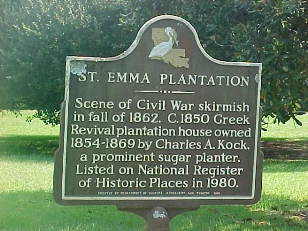
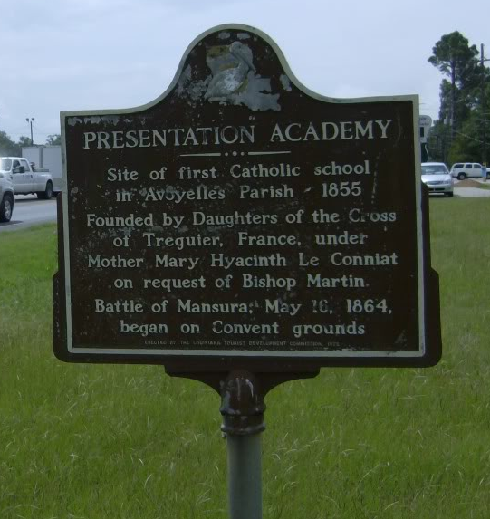
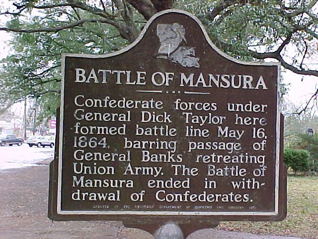
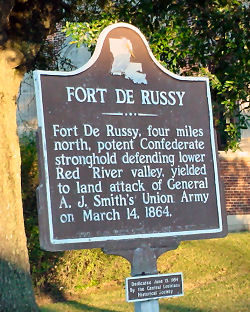
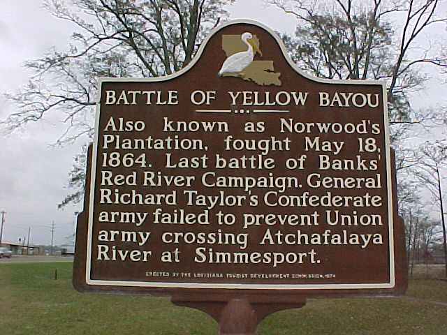
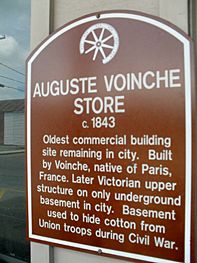
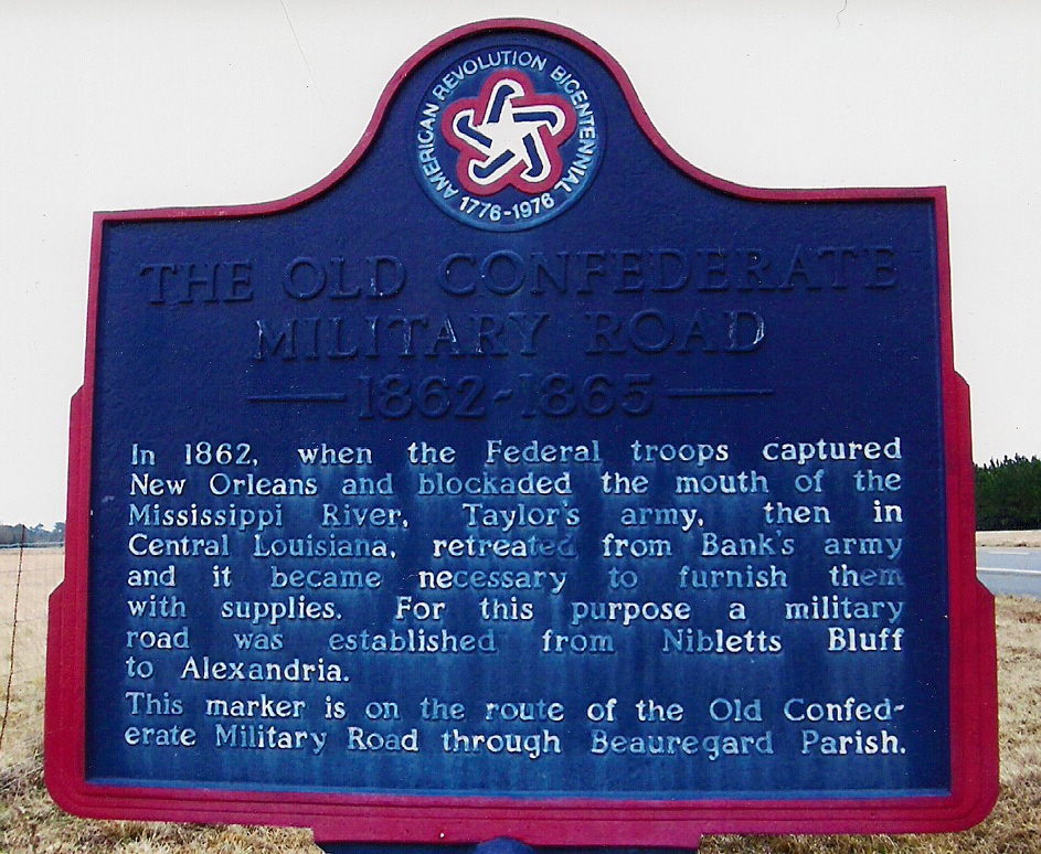
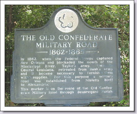
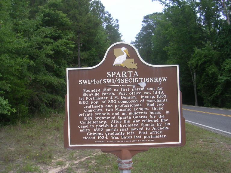
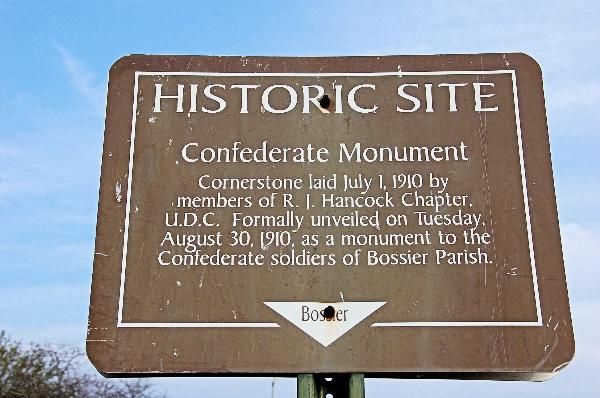
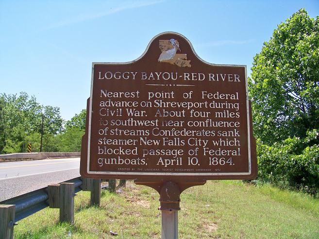
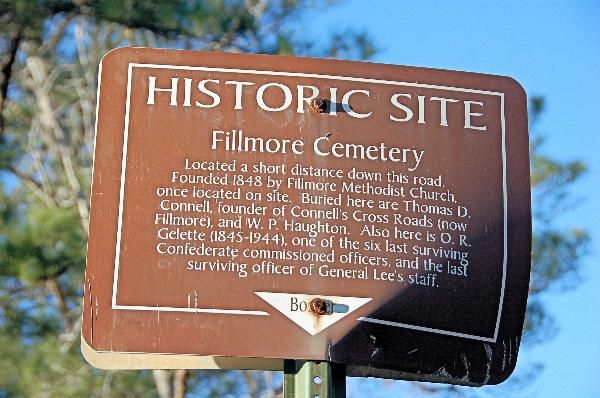
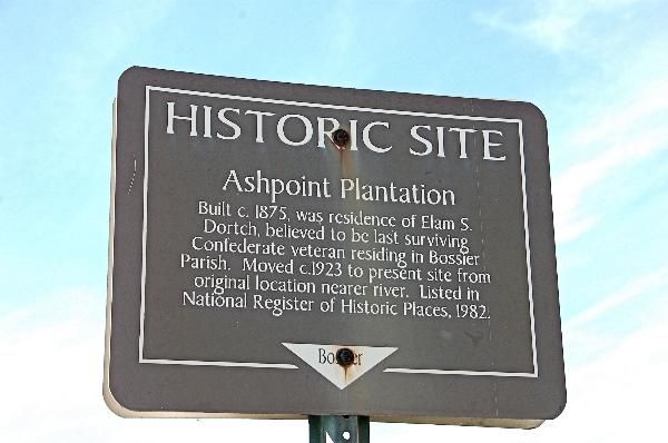
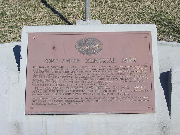
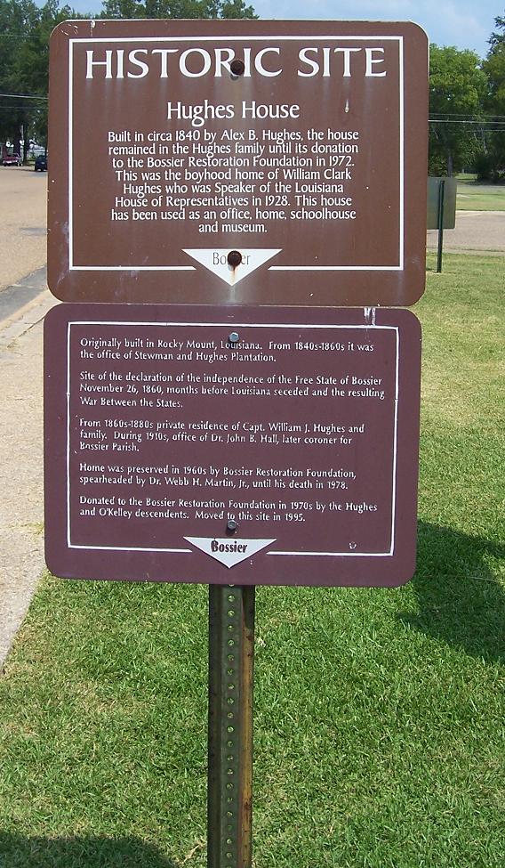
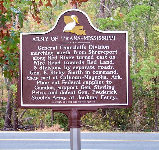
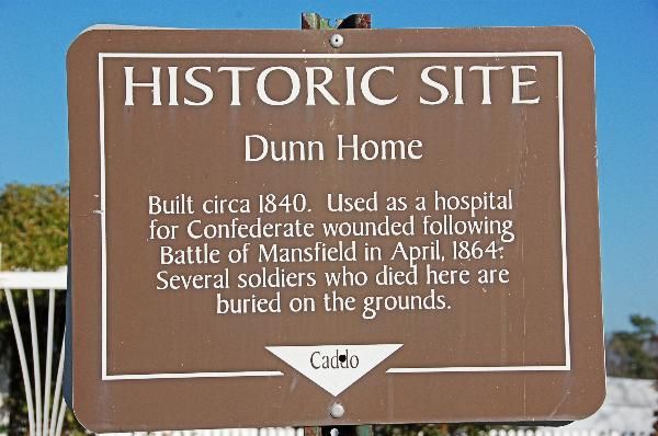
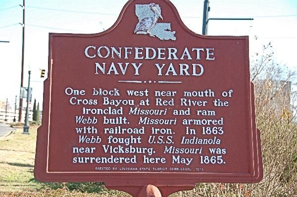
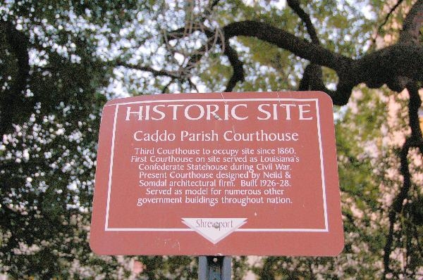
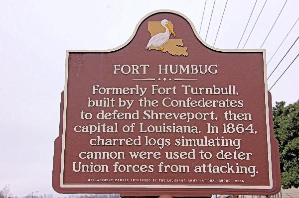
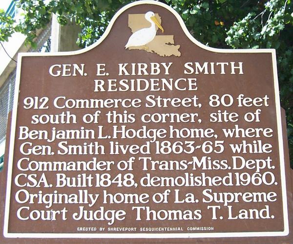
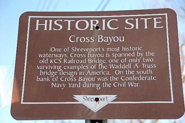
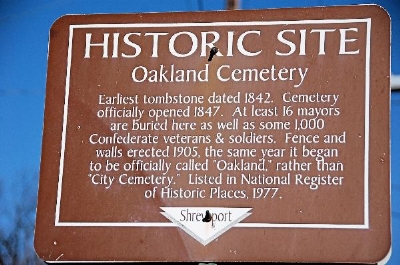
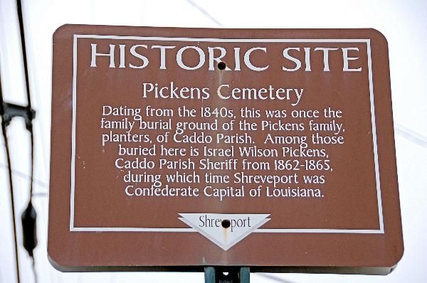
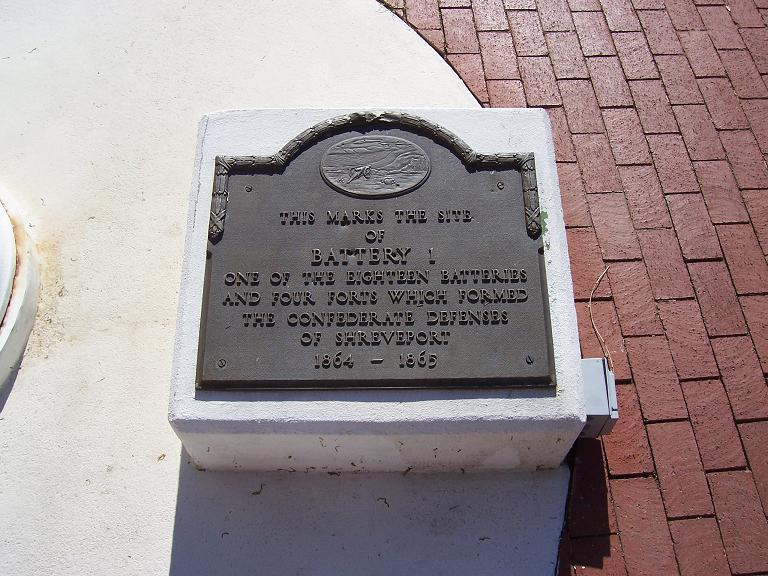
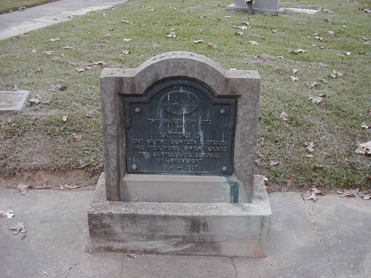
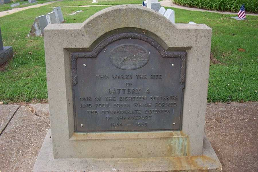
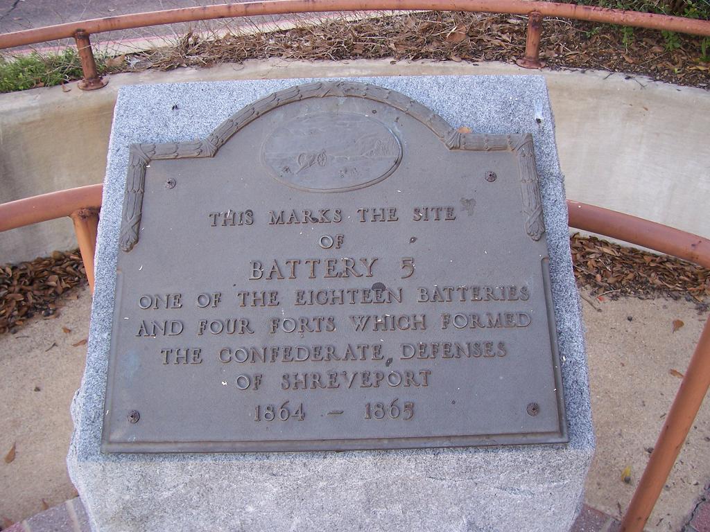
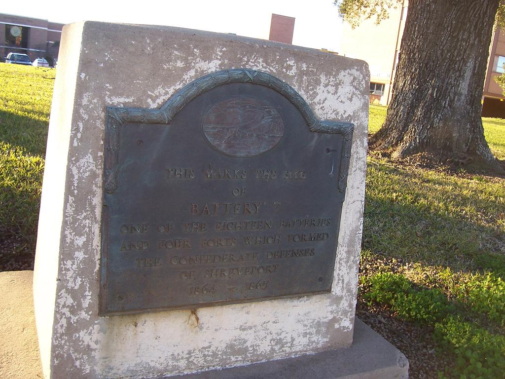
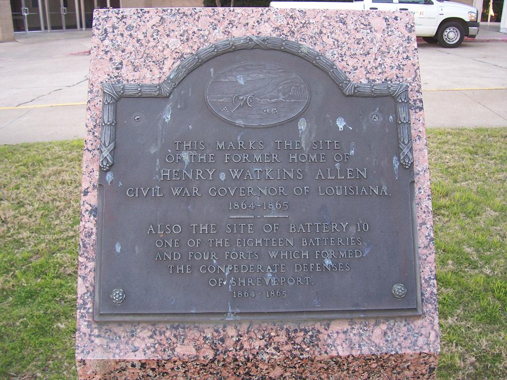
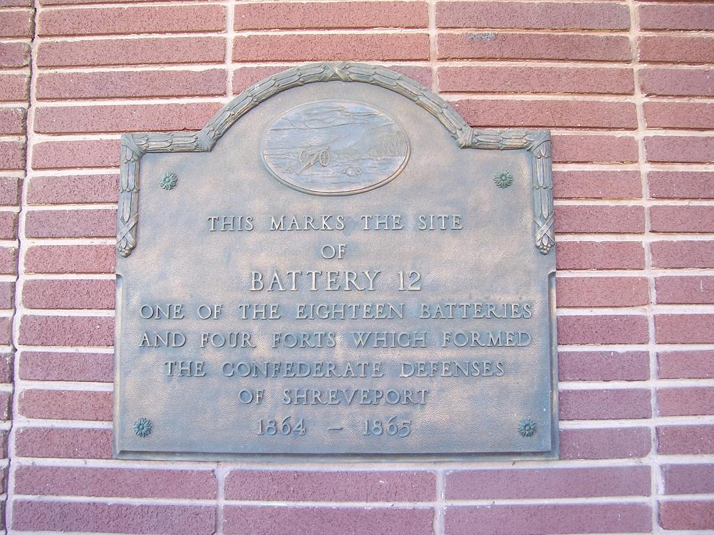
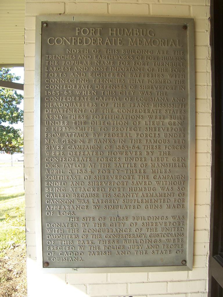
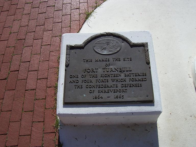
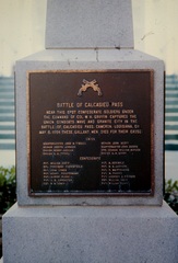
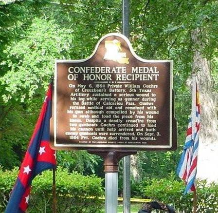
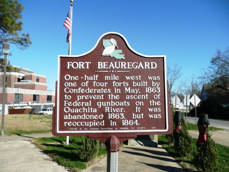
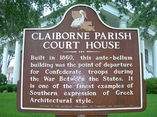
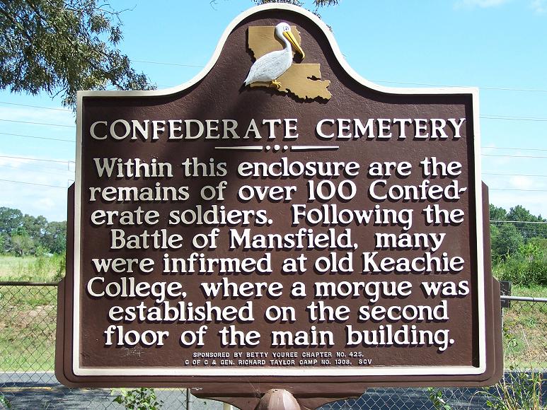
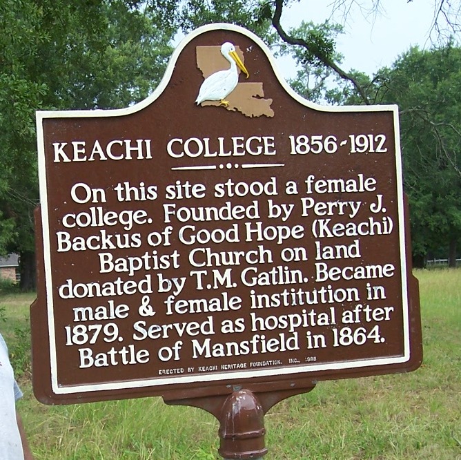
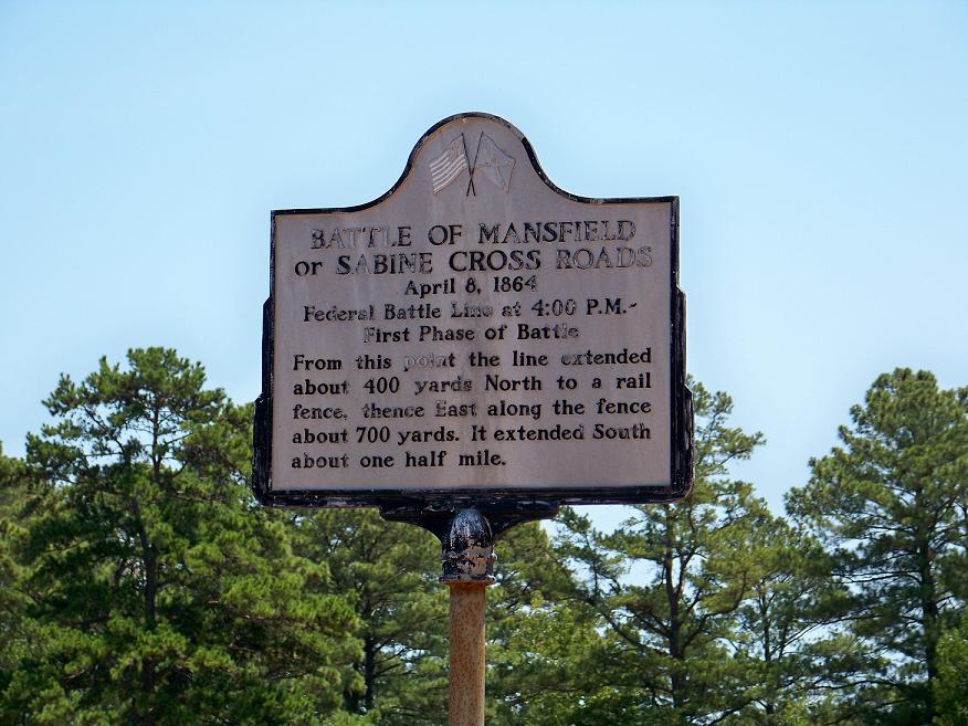
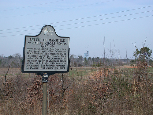
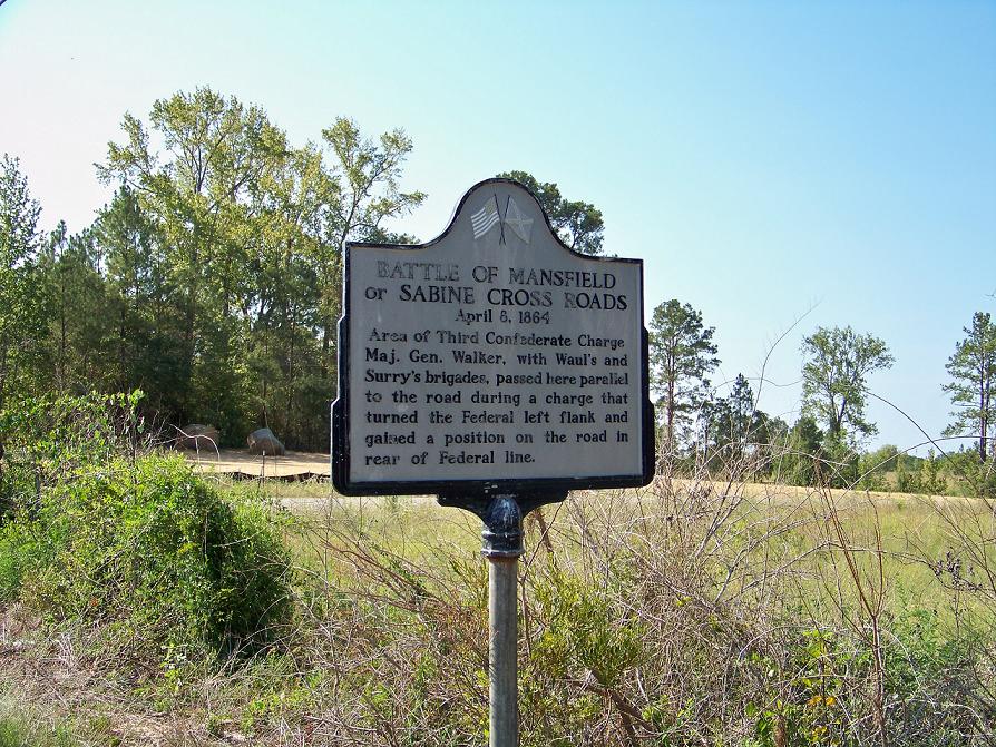
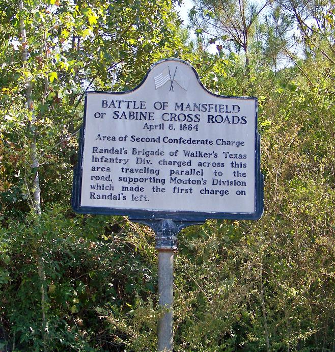
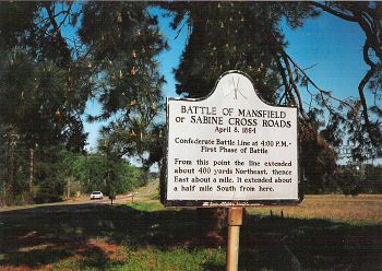
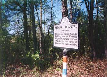
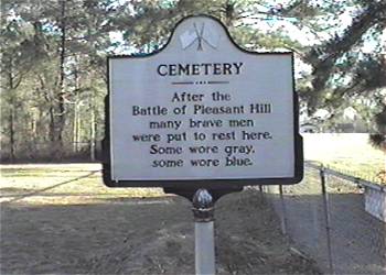
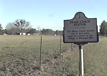
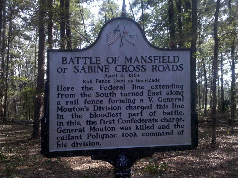
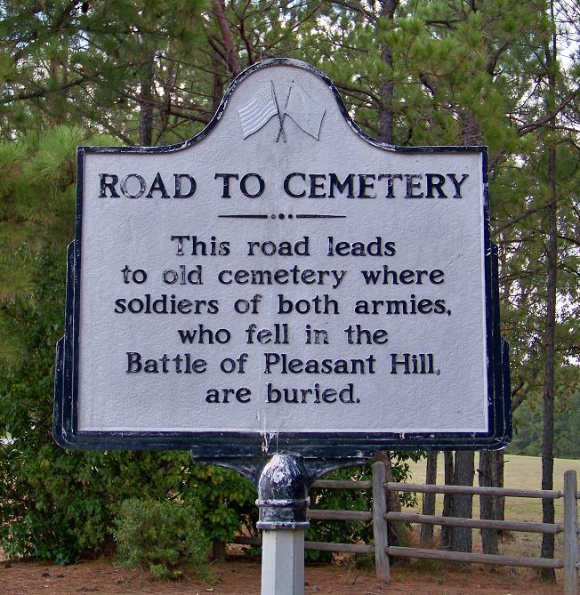
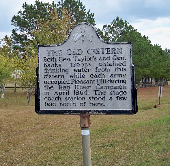
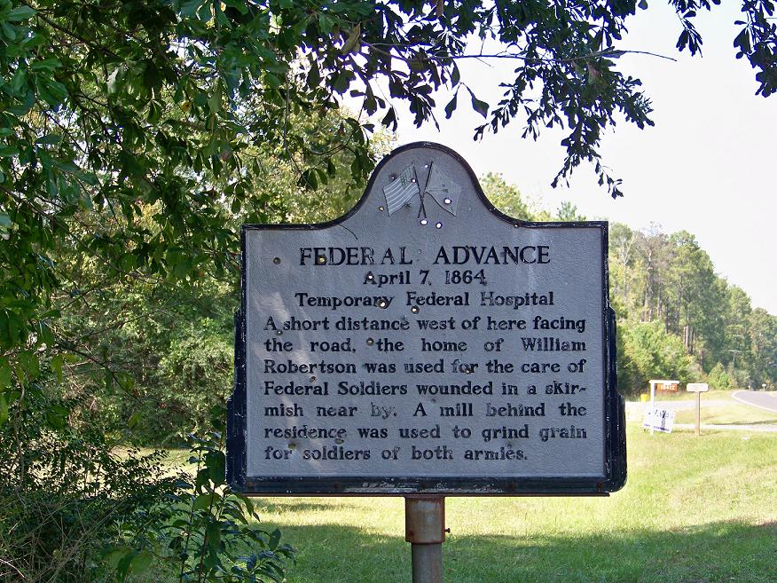
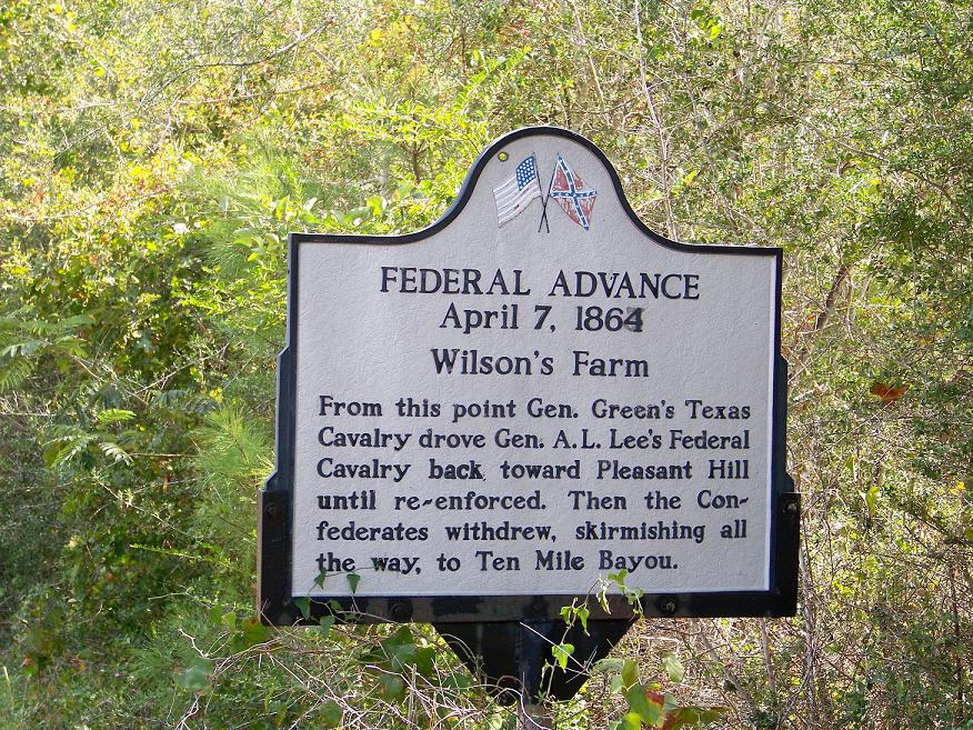
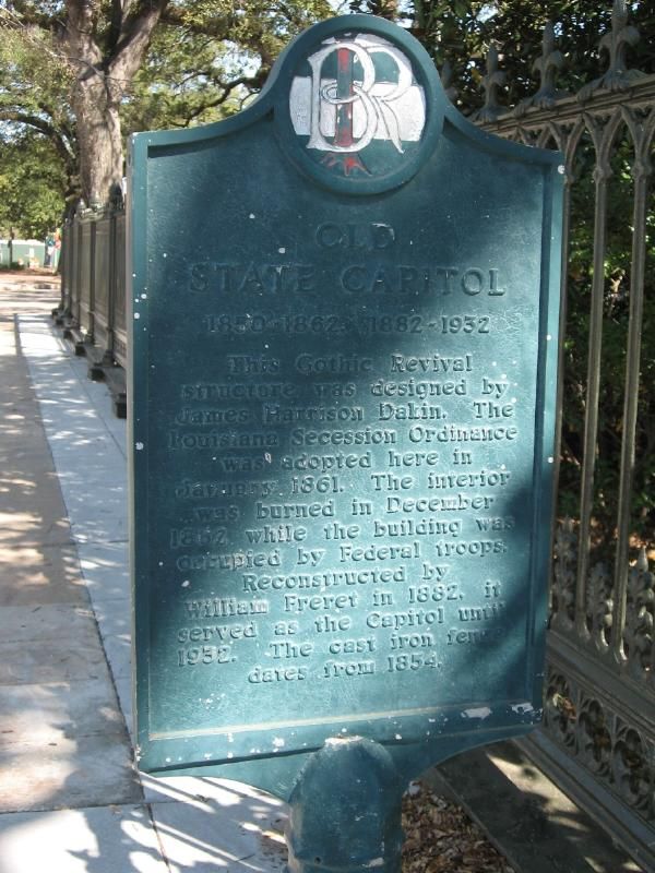
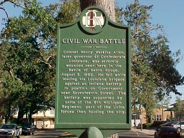
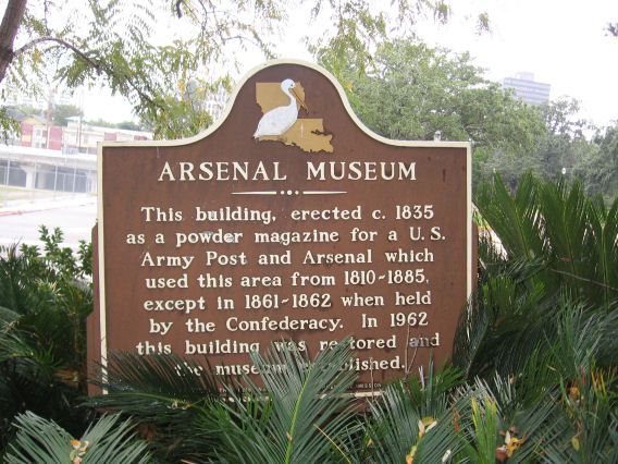
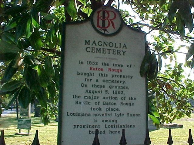
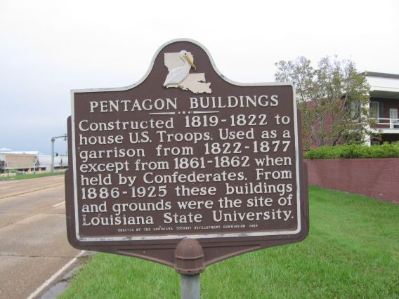
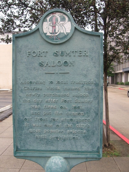
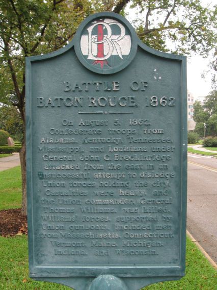
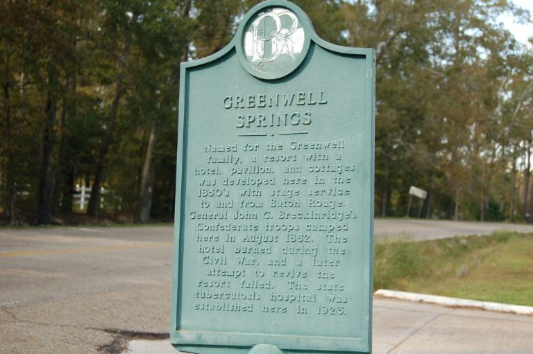
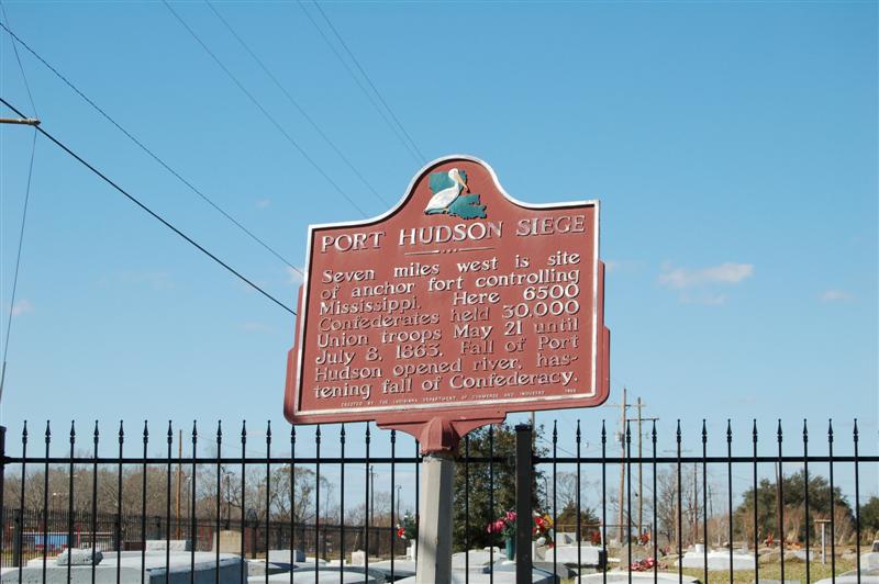
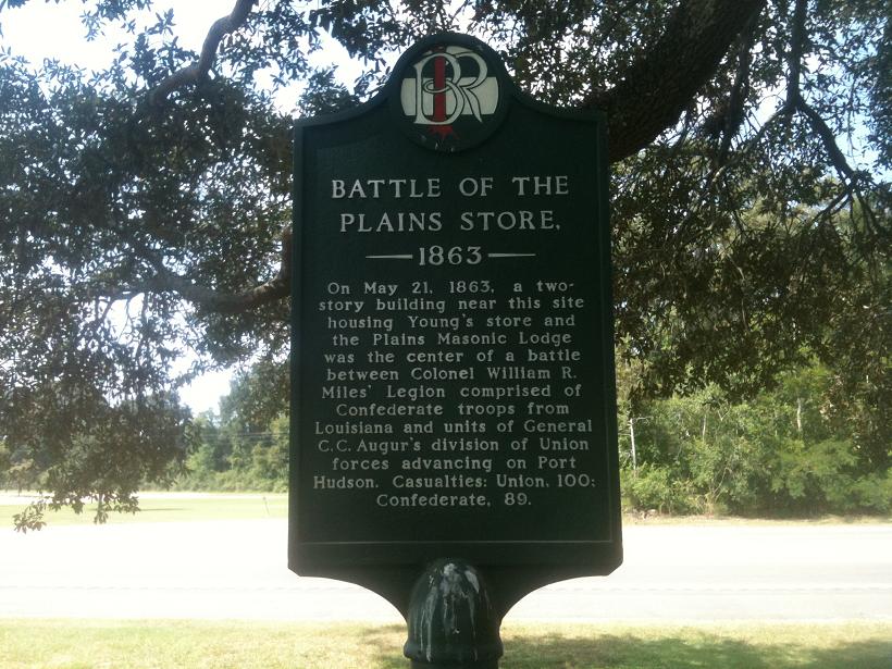
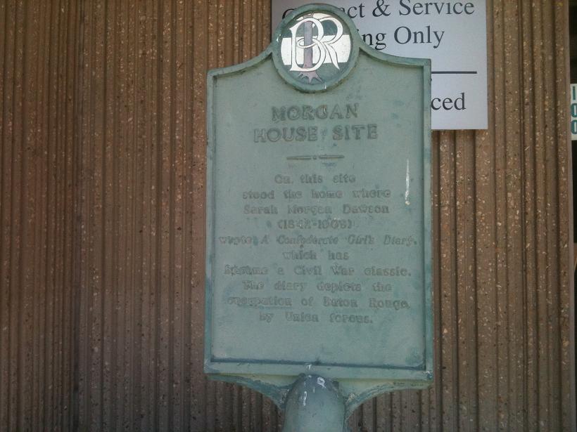
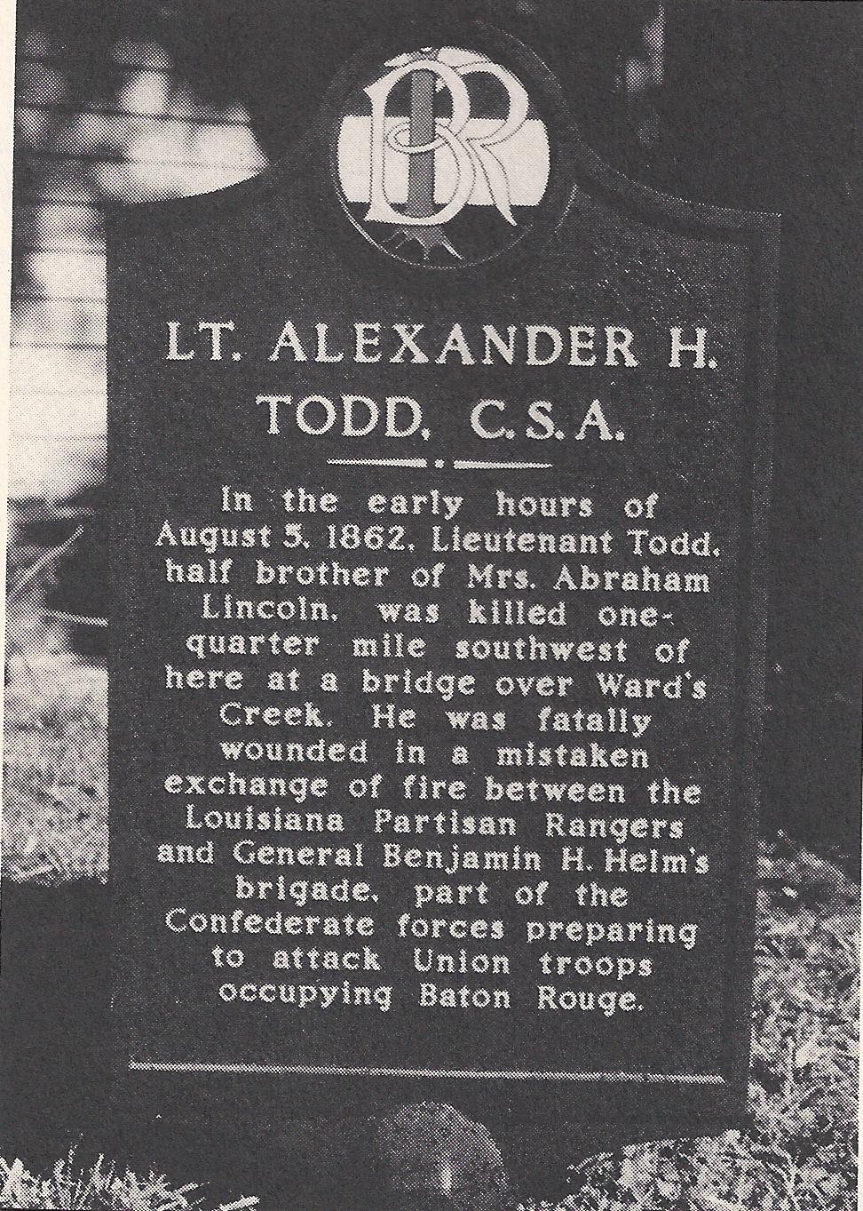
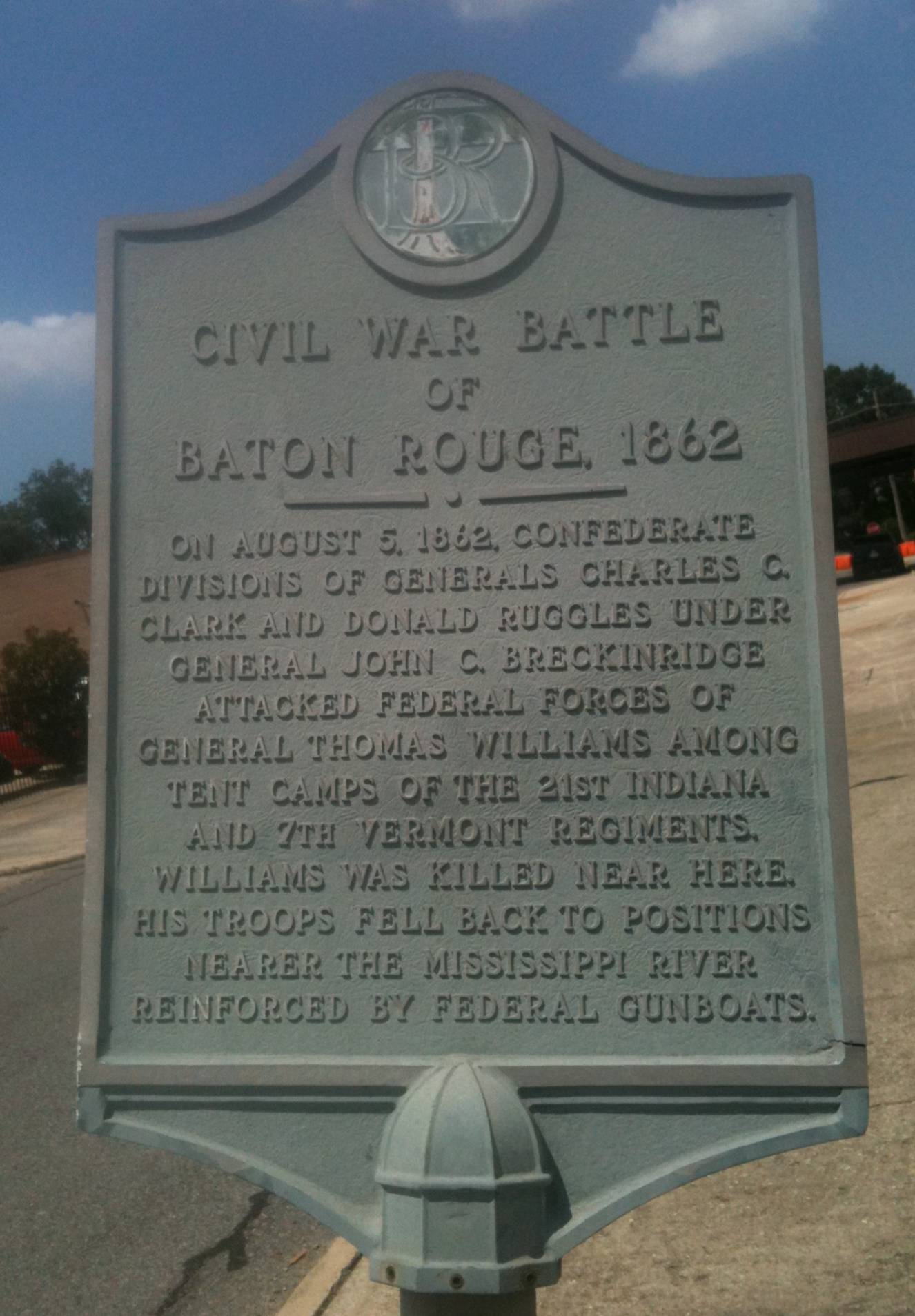
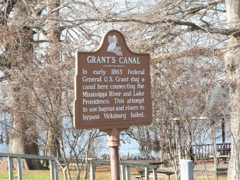
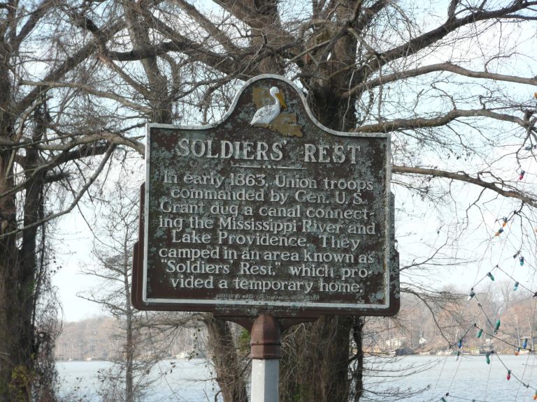
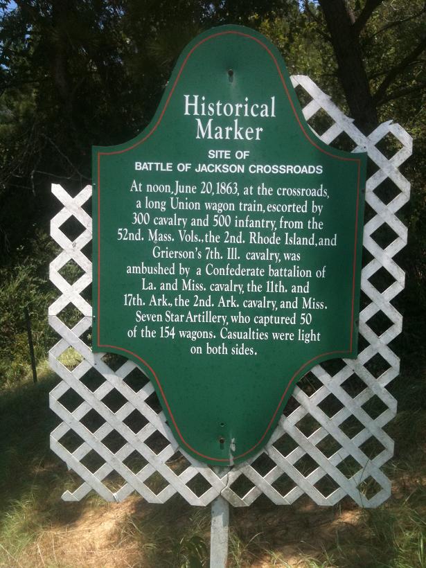
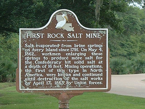
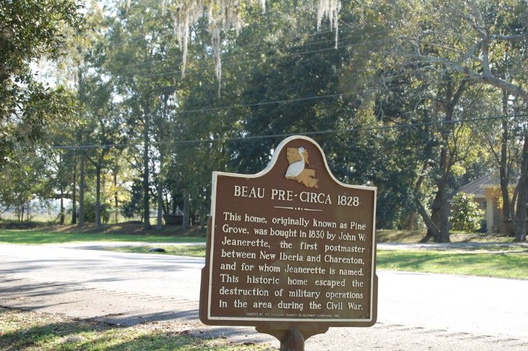
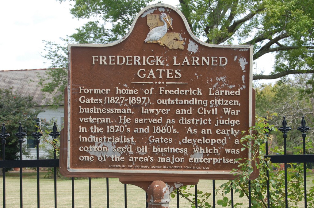
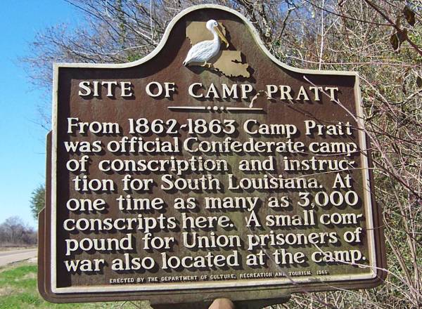
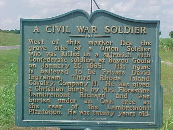
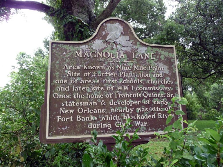
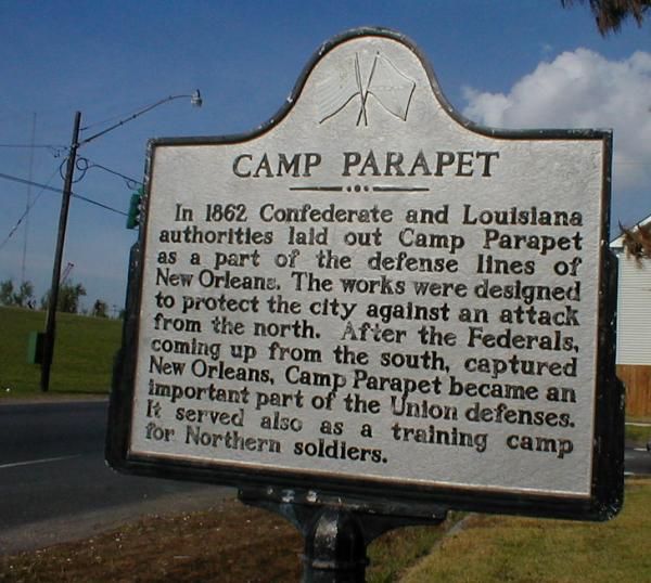
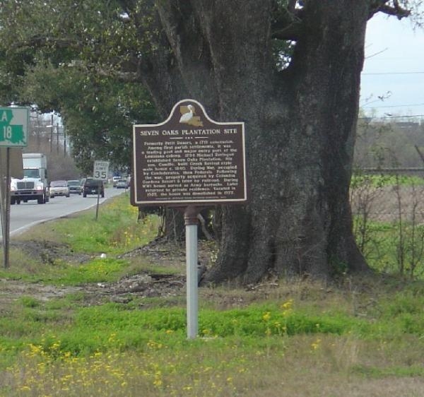
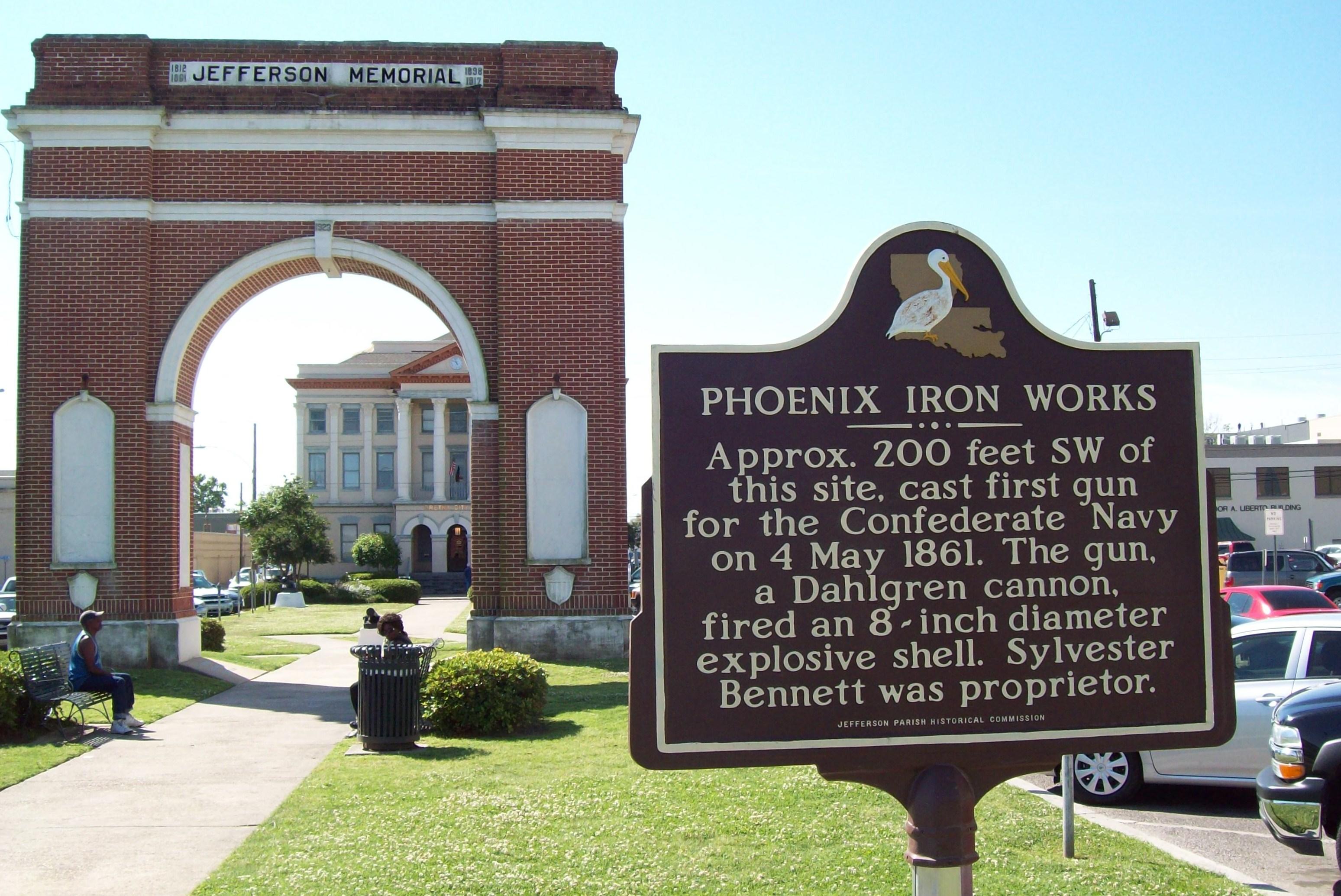
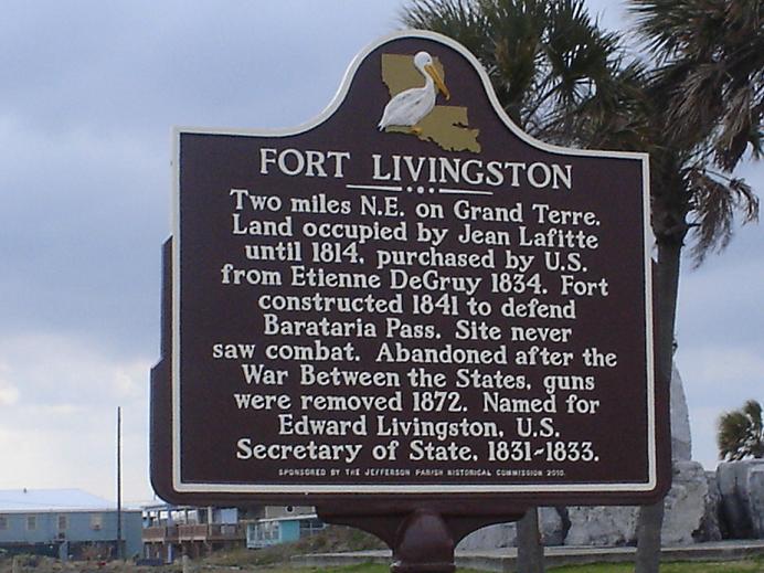
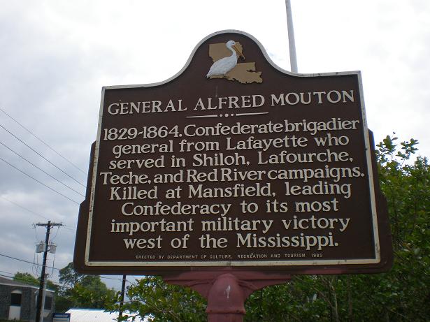
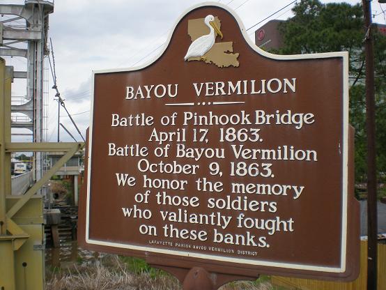
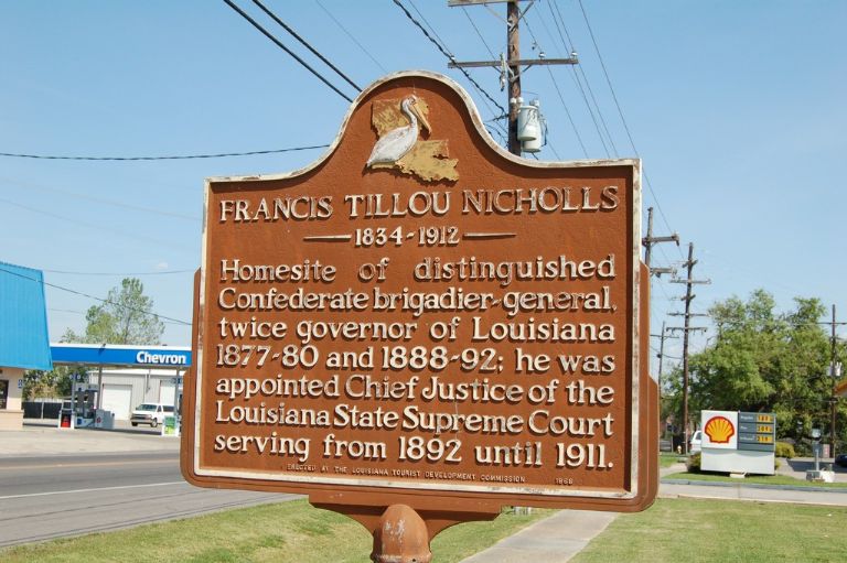
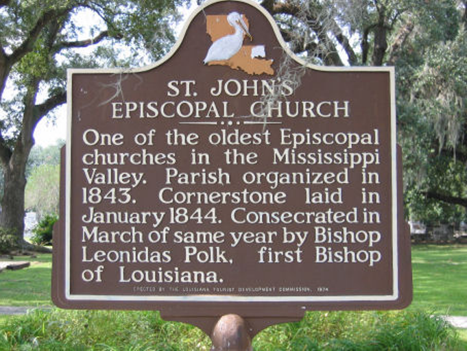
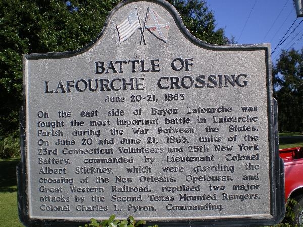
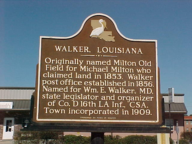
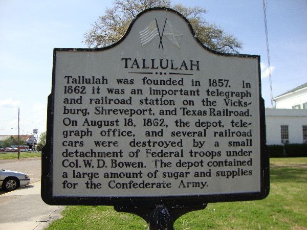
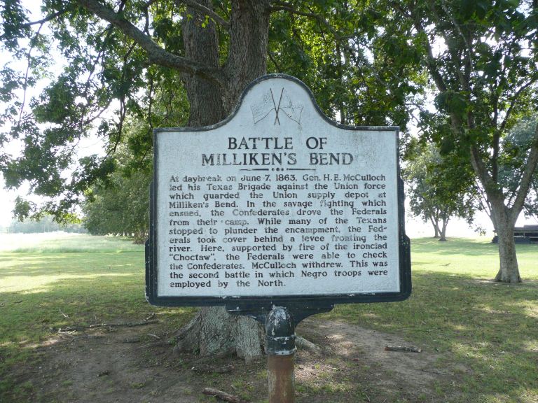
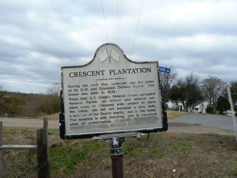
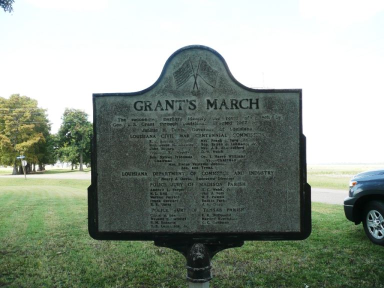
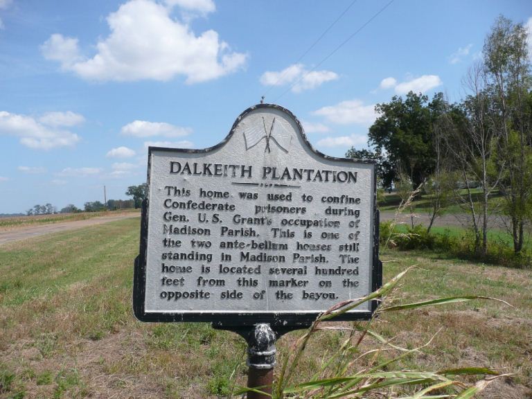
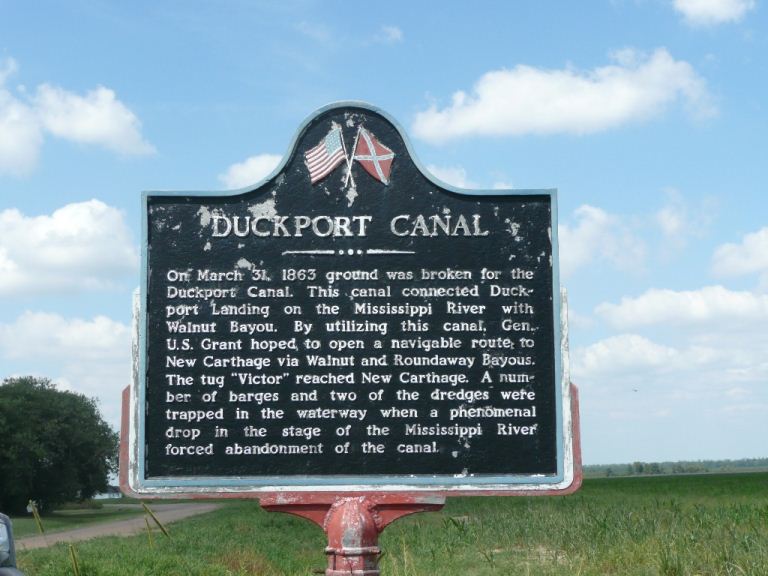
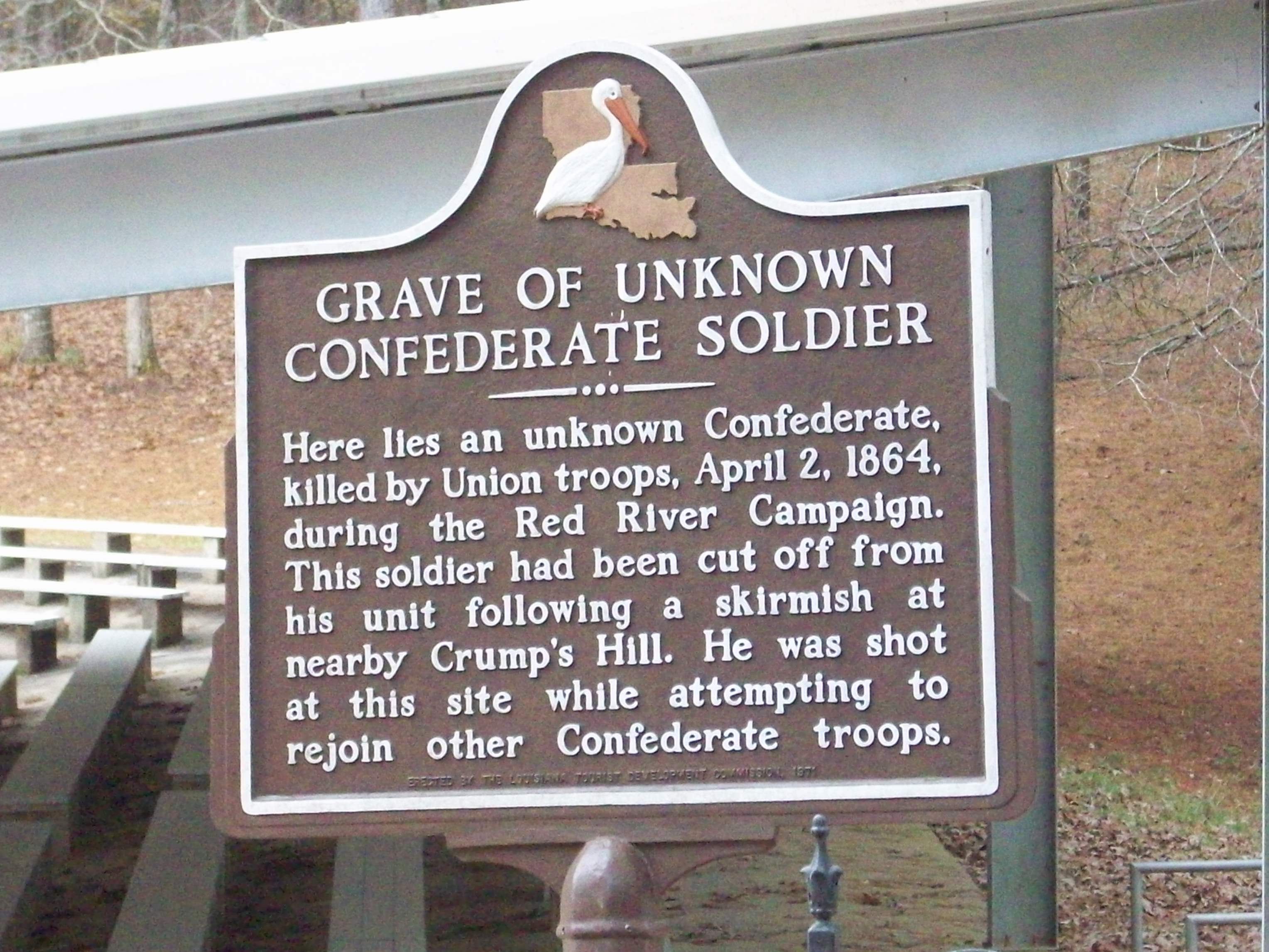
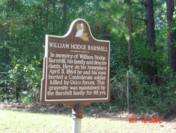
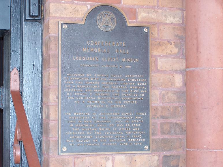
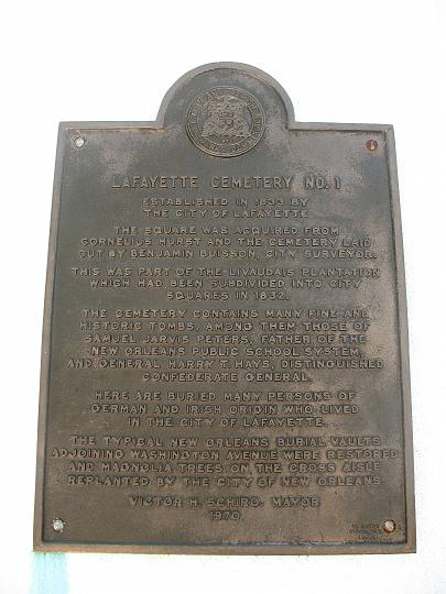
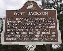
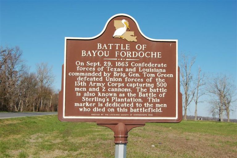
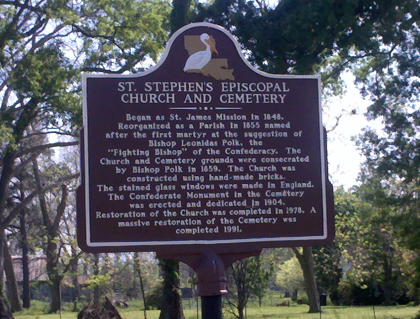
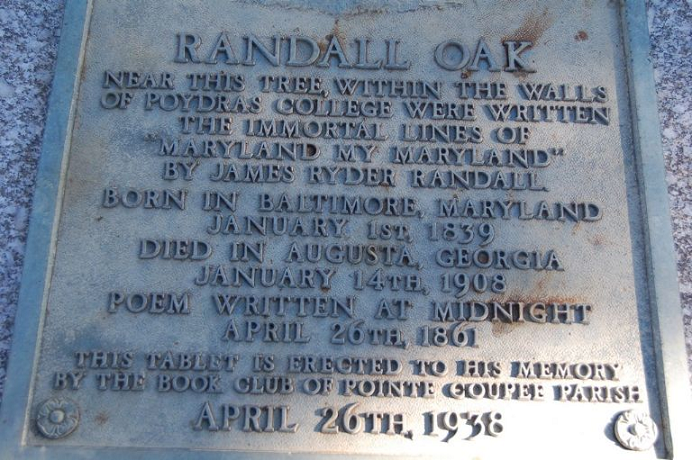
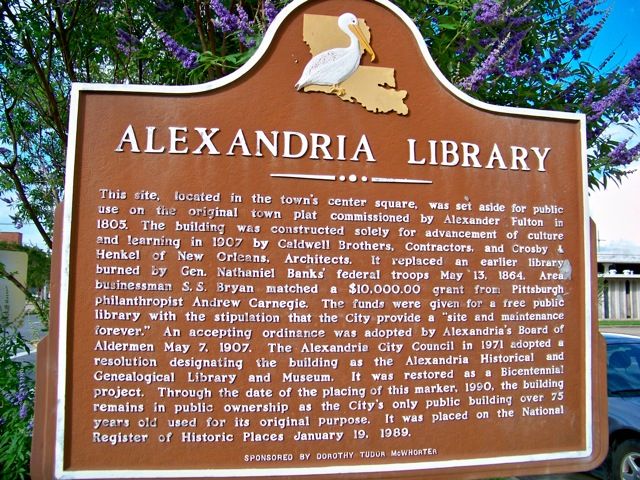
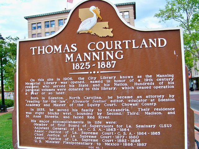
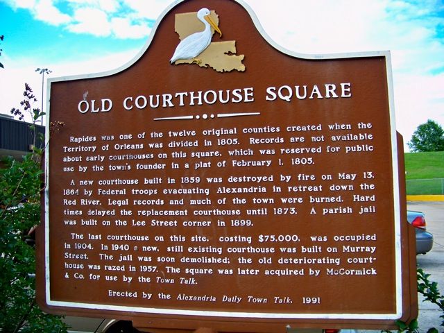
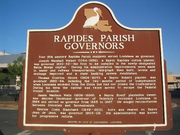
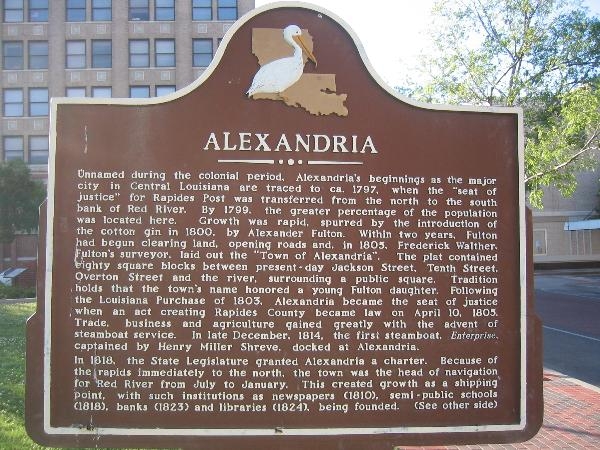
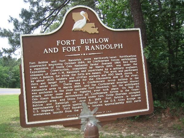
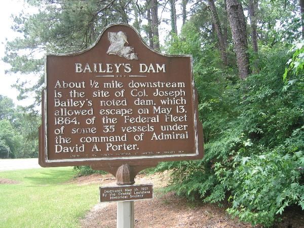
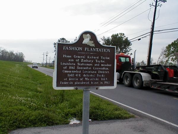
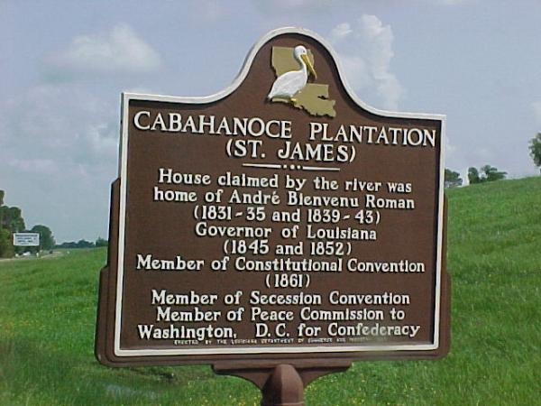
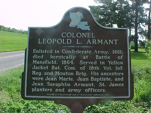
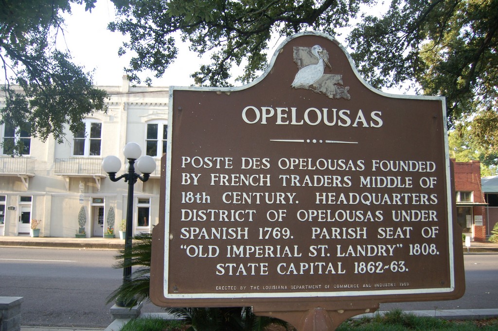
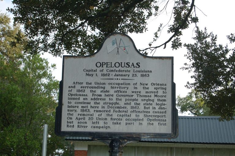
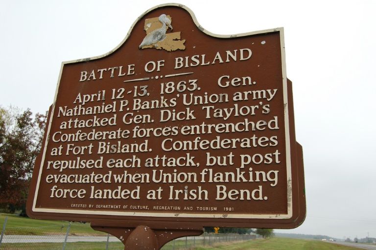
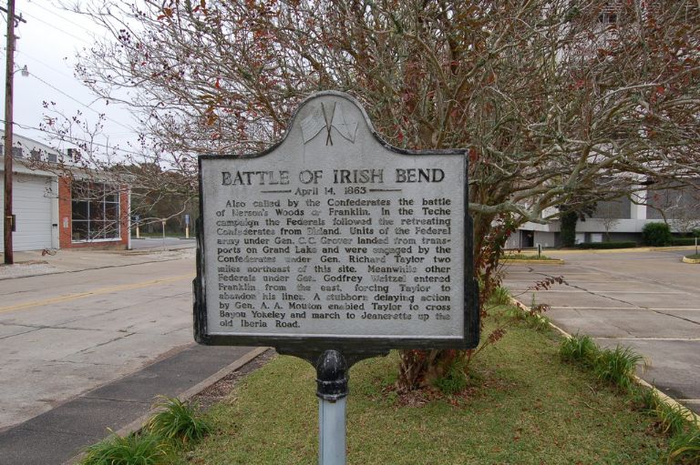
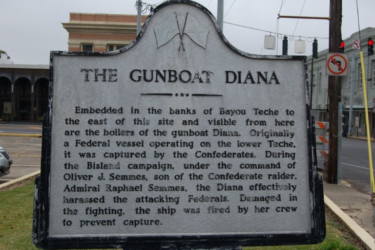
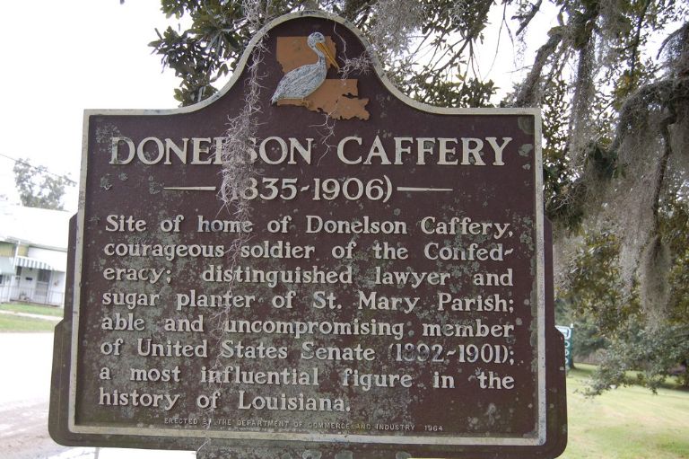
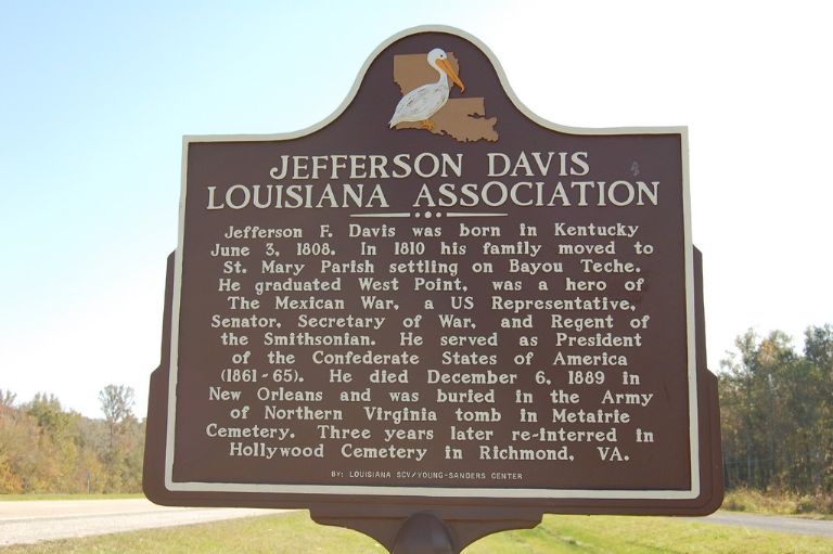
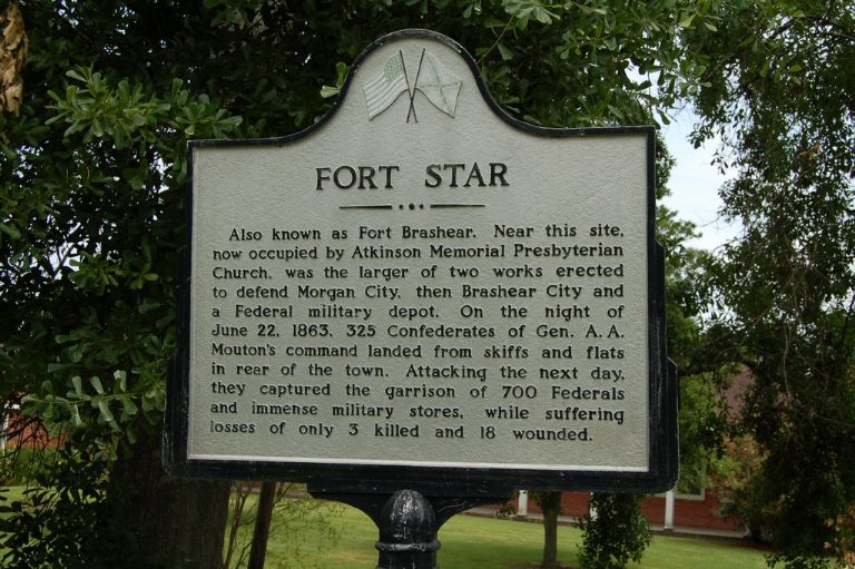
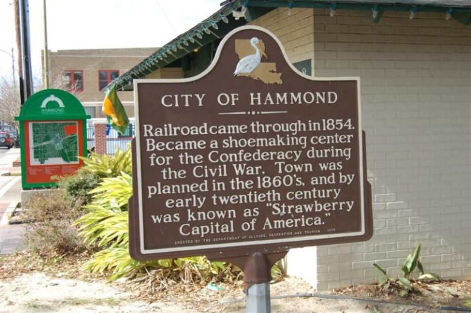
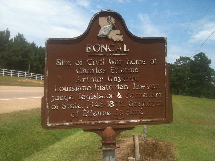
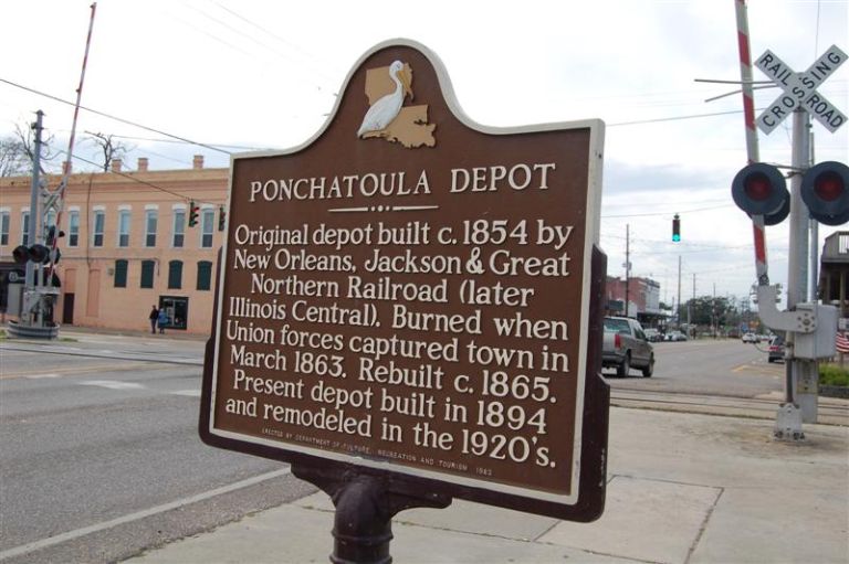
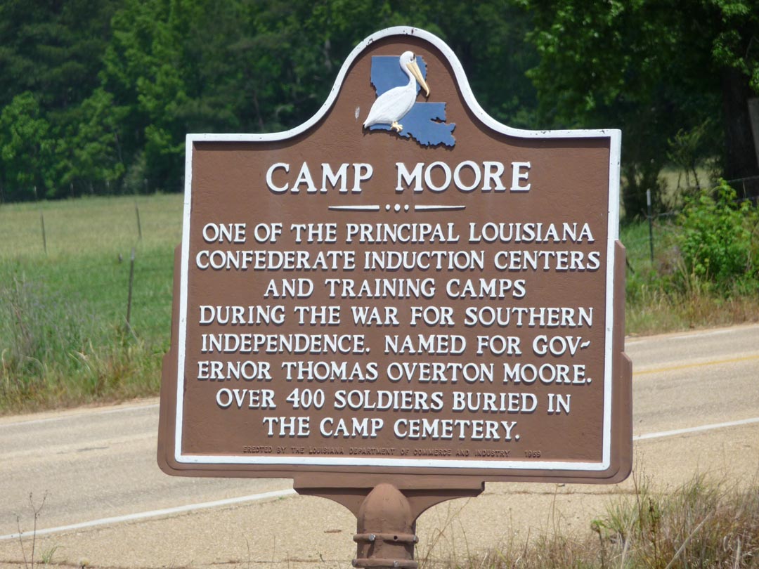
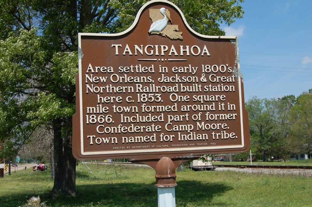
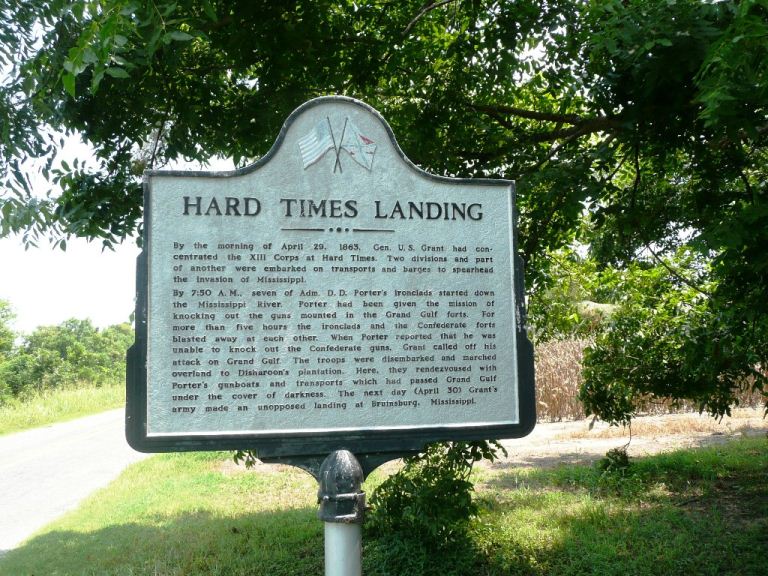
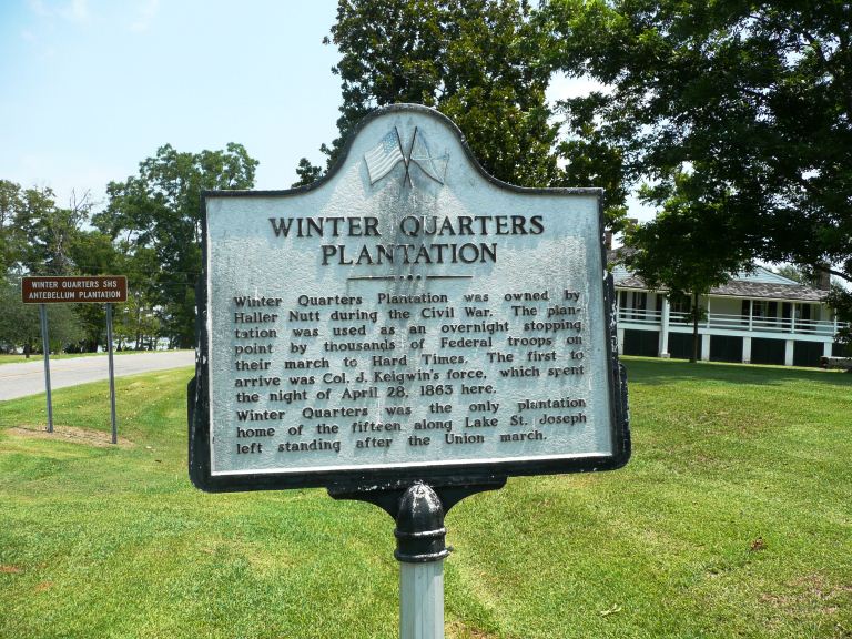
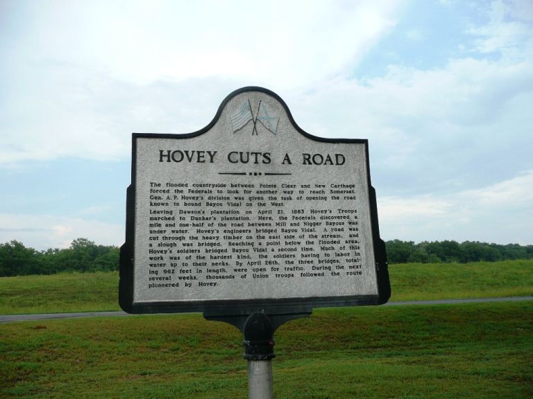
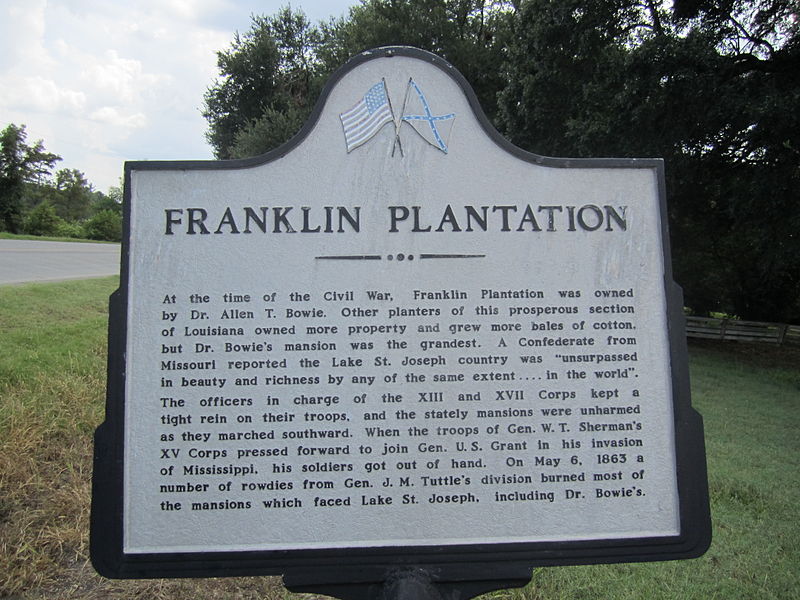
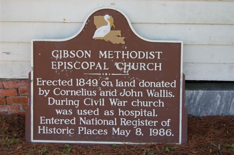
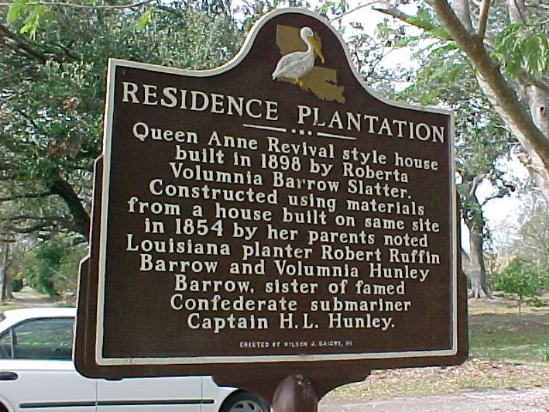
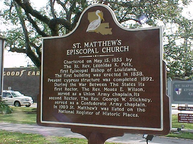
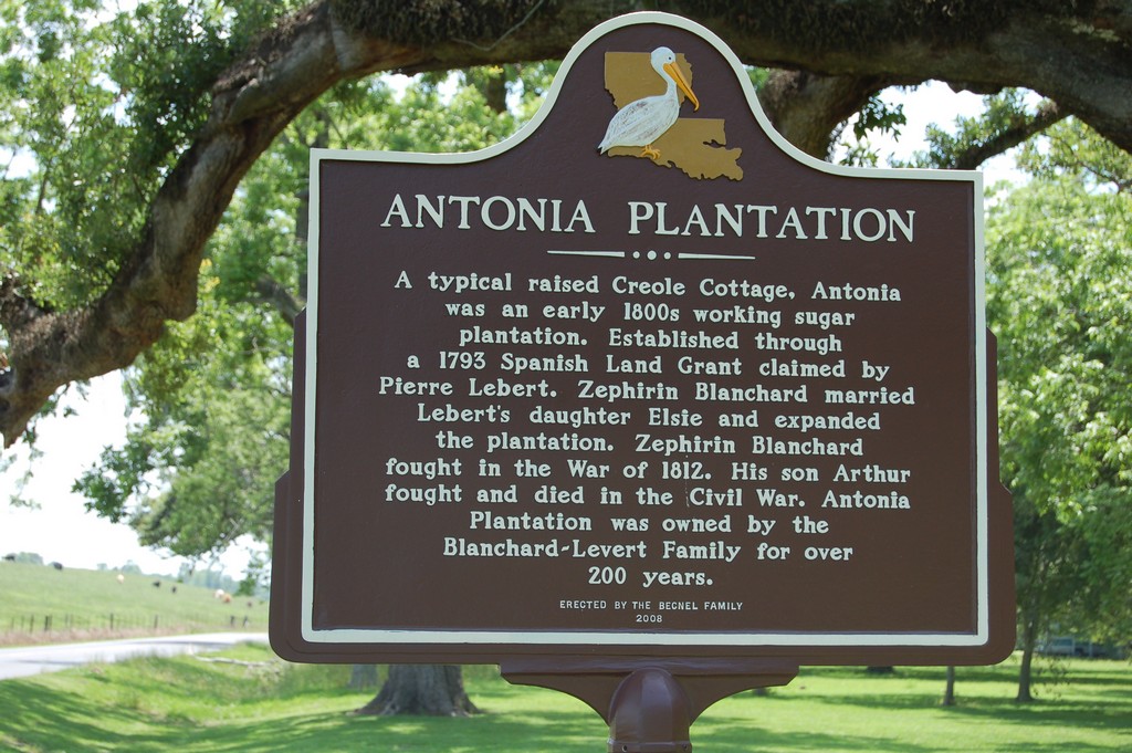
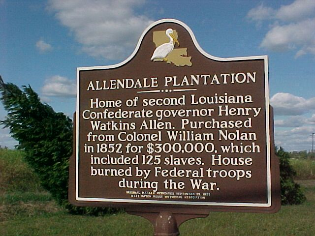
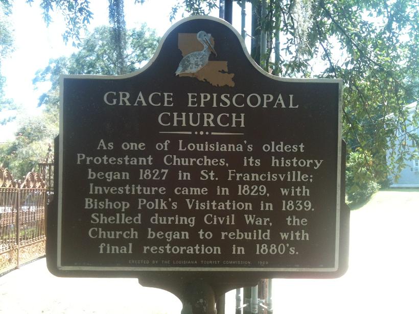